Explore entries from James Cook’s Endeavour journal for August 1770, as the ship travelled from Endeavour River to Possession Island.
Images and transcripts kindly supplied by the National Library of Australia.
Transcripts
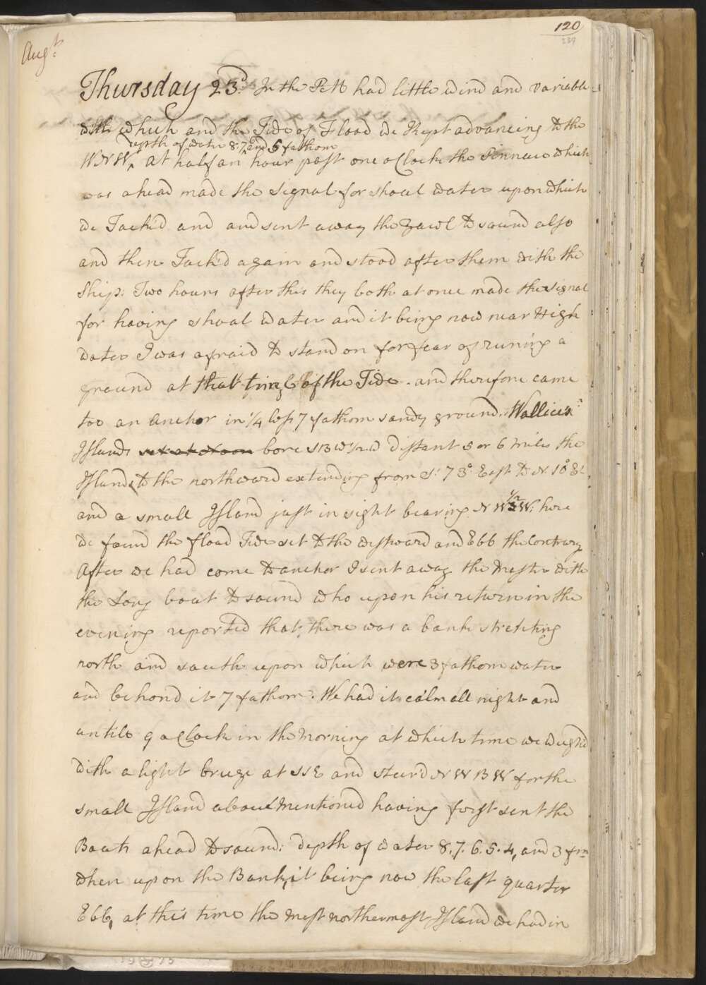
Thursday 23d In the PM had little wind and variable with which and the Tide of Flood we Kept advancing to the WNW depth of Water 8, 7, 6 and 5 fathom At half an hour past one oClock the Pinnace which was ahead made the Signal for shoal water upon which we Tack'd and sent away the Yawl to sound also and then Tack'd again and stood after them with the Ship: Two hours after this they both at once made the Signal for having shoal water and it being now near High water I was afraid to stand on for fear of runing a ground at that time of the Tide — and therefore came to an Anchor in ¼ less 7 fathom sandy ground. Wallice's Islands set at Noon bore SBW ½ W distant 5 or 6 Miles the Islands to the northward extending from St 73° East to N. 10° Et and a small Island just in sight bearing NW ½ W; here we found the flood Tide set to the westward and Ebb the Contrary
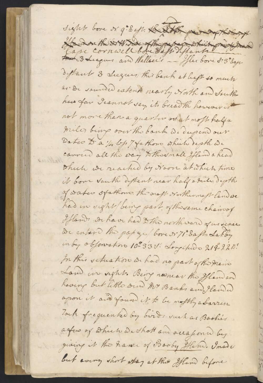
After we had come to anchor I sent away the Master with the Long boat to sound who upon his return in the evening reported that there was a bank stretching north and south upon which were 3 fathom water and behond it 7 fathom. We had it calm all night and untill 9 oClock in the Morning at which time we weigh'd with a light breeze at SSE and steer'd NWBW for the small Island above Mentioned having first sent the Boats ahead to sound; depth of water 8, 7, 6, 5, 4, and 3 fm when upon the Bank, it being now the last quarter Ebb, at this time the Most northermost Island we had in sight bore N 9° East, the SW point of the largest Island on the NW side of the passage, which point I nam'd Cape Cornwell bore East distant — two 3 Leagues and Wallace's — Isles bore So 3° East distant 3 Leagues;
this bank at least so much as we sounded extends nearly North and South how far I cannot say, its breadth however is not more than a quarter or at most half a mile; being over the bank we deepen'd our water to a ¼ less 7 fathom which depth we carried all the way to the small Island a head which we reached by Noon, at which time it bore South distant near half a Mile, depth of water 5 fathom, the most Northermost land we had in sight / being part of the same chain of Islands we have had to the northward of us sence we enterd the passage / bore N 71° East — Latd by in by observation 10°..33' St Longitude 219°..22' Wt In this situation we had no part of the Main Land in sight.
Being now near the Island and having but little wind Mr Banks and I landed upon it and found it to be mostly a barren Rock frequented by birds such as Boobies a few of which we Shott and occasioned my giving it the Name of Booby Island. I made but avery short stay at this Island before I returnd to the Ship.
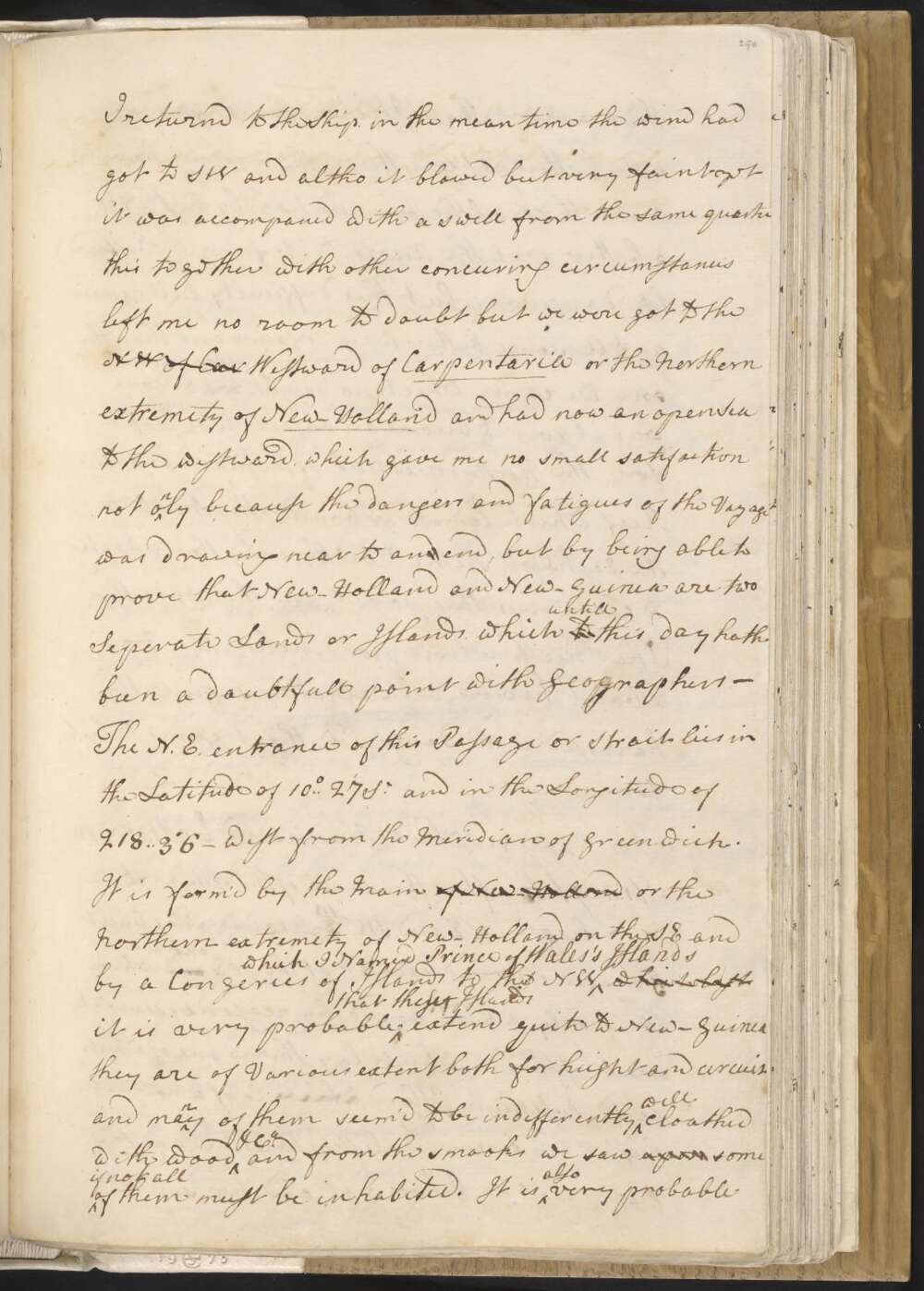
in the mean time the wind had got to the SW and altho it blowed but very faint yet it was accompaned with a swell from the same quarter this together with other concuring circumstances left me no room to doubt but we were got to the NW of Car Westward of Carpentaria or the Northern extremety of New-Holland and had now an open Sea to the westward, which gave me no small satisfaction not only because the danger and fatigues of the Voyage was drawing near to and end, but by being able to prove that New-Holland and New-Guinea are 2 Seperate Lands or Islands, which to untill this day hath been a doubtful point with Geographers —
The N.E. entrance of this Passage or Strait lies in the Latitude of 10°..27' So and in the Longitude of 218°..36 — West from the Meridian of Greenwich. It is form'd by the Main of New-Holland, or the Northern extremety of New-Holland on the SE and by a Congeries of Islands to the NW which I Named Prince of Wales's Islands which last It is very Probable that these Islands extend quite to New-Guinea they are of Various extend both for height and circuit and many of them seem'd to be indifferently well cloathed with wood &Ca and from the smooks we saw upon some if not all of them must be inhabited.
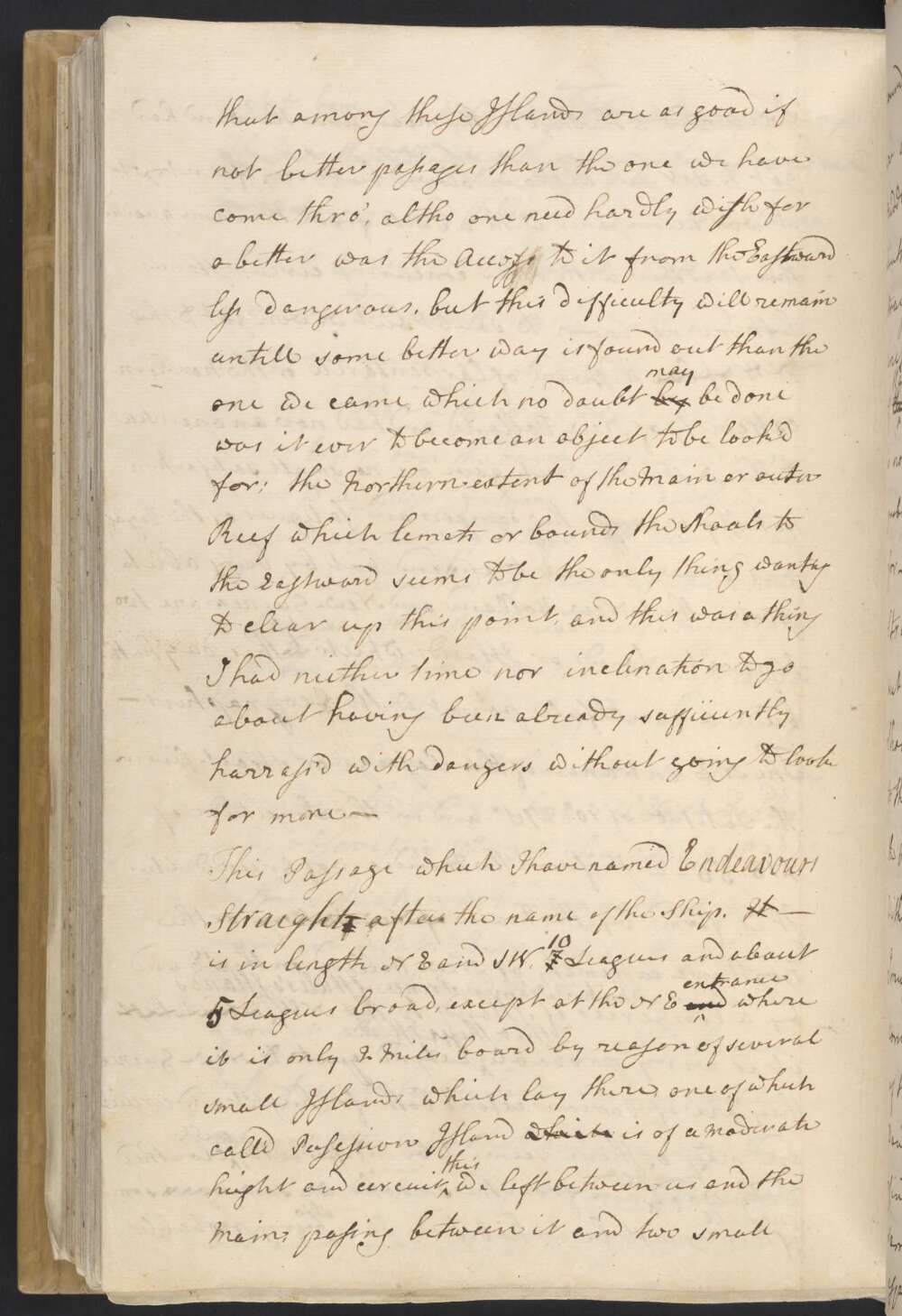
It is also very probable that among these Islands are as good if not better passages than the one we have come thro', altho one need hardly wish for a better was the Access to it from the Eastward less dangerous, but this difficulty will remain untill some better way is found out than the one we came, which no doubt by may be done was it ever to become an object to be look'd for; the Northern extent of the Main or outer Reef which limets or bounds the Shoals to the Eastward seems to be the only thing wanting to clear up this point, and this was a thing I had neither time nor inclination to go about having been already sufficiently harrass'd with dangers without going to look for more —
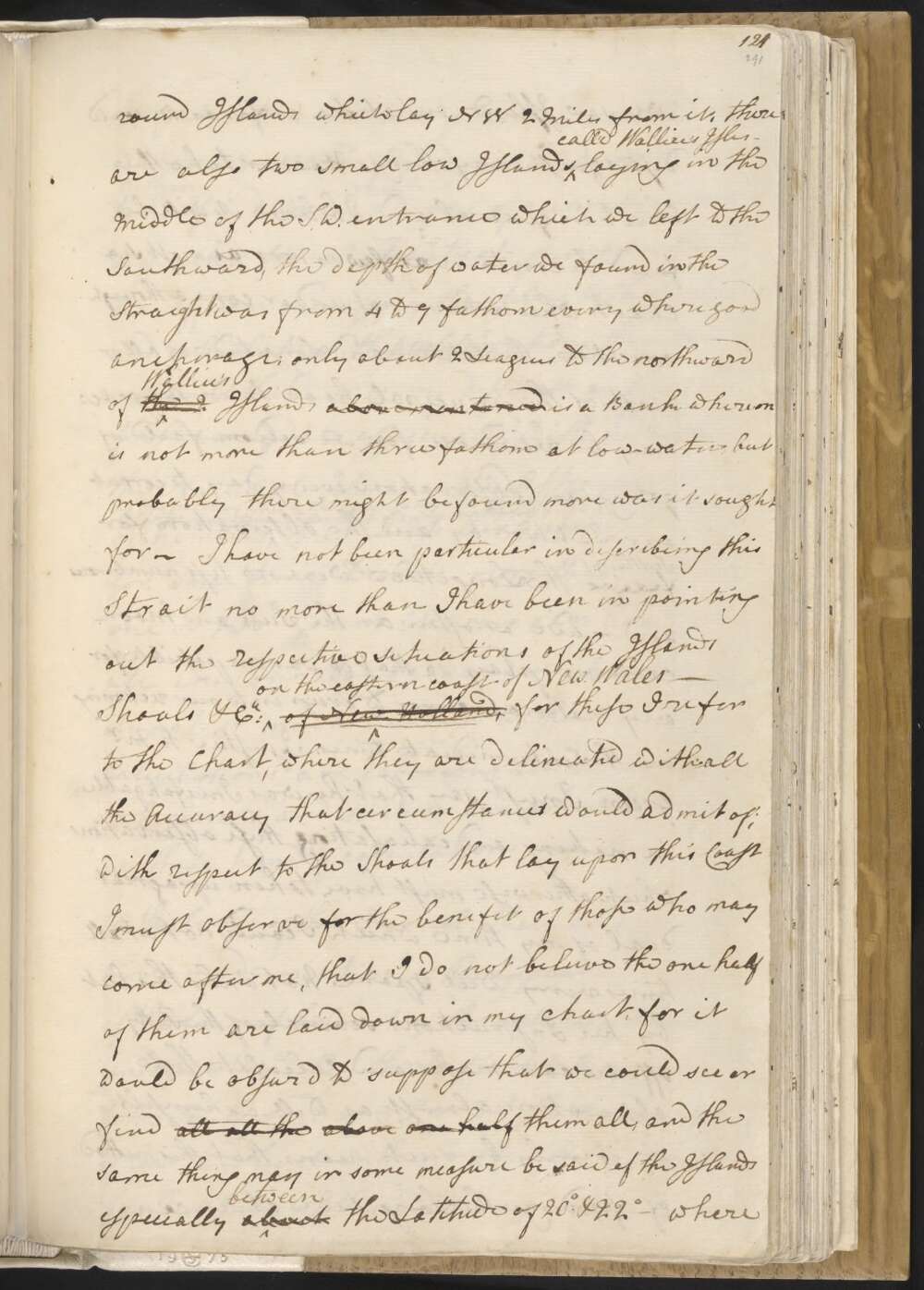
This passage, which I have named Endeavours Straights after the name of the Ship. It — is in length NE and SW 7 10 Leagues and about 4 5 leagues broad, except at the NE and entrance where it is only 2 Miles broad by reason of several small Islands which lay there, one of which call'd Posession Island which is of a moderate height and circuit this we left between us and the Main, passing between it and two small round Islands which lay NW 2 Miles from it, there are also two small low Islands call'd Wallice's Isles — laying in the Middle of the S.W. entrance which we left to the Southward, the depth of water we found in the Straight was from 4 to 9 fathom every where good anchorage; only about 2 Leagues to the northward of the I Wallice's Islands above mentioned is a Bank whereon is not more than three fathom at low-water, but probably there might be found more was it sought for —
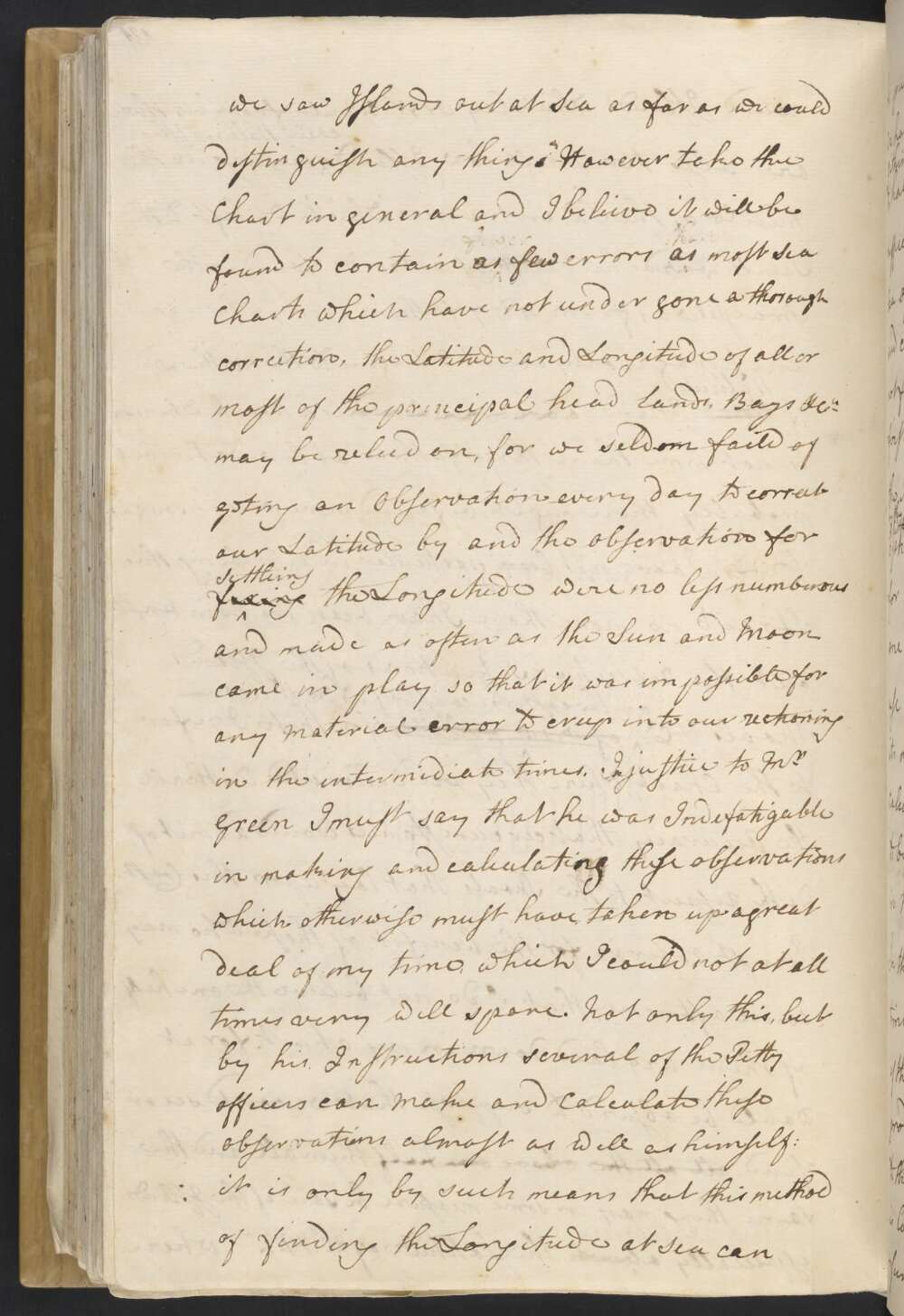
I have not been particular in discribing this Strait no more than I have been in pointing out the respective situations of the Islands Shoals &Ca on the eastern coast of New Wales — of New Holland, for these I refer to the Chart, where they are delineated with all the Accuracy that circumstances would admit of; with respect to the Shoals that lay upon this Coast I must observe for the benifit of those who may come after me, that I do not beleive the one half of them are laid down in my chart, for it would be obsurd to suppose that we could see or find all all the above one half them all, and the same thing may in some measure be said of the Islands especially about between the Latitude of 20° & 22° — where we saw Islands out at Sea as far as we could distinguish any thing. However take the Chart in general and I beleive it will be found to contain as few errors as most Sea Charts which have not undergone a thorough correction, the Latitude and Longitude of all or most of the principal head lands. Bays &Ca may be relied on, for we seldom faild of geting an Observation every day to correct our Latitude by and the observation for fixing Settleing the Longitude were no less numberous and made as often as the Sun and Moon came in play, so that it was impossible for any material error to creep into our reckoning in the intermidiate times.
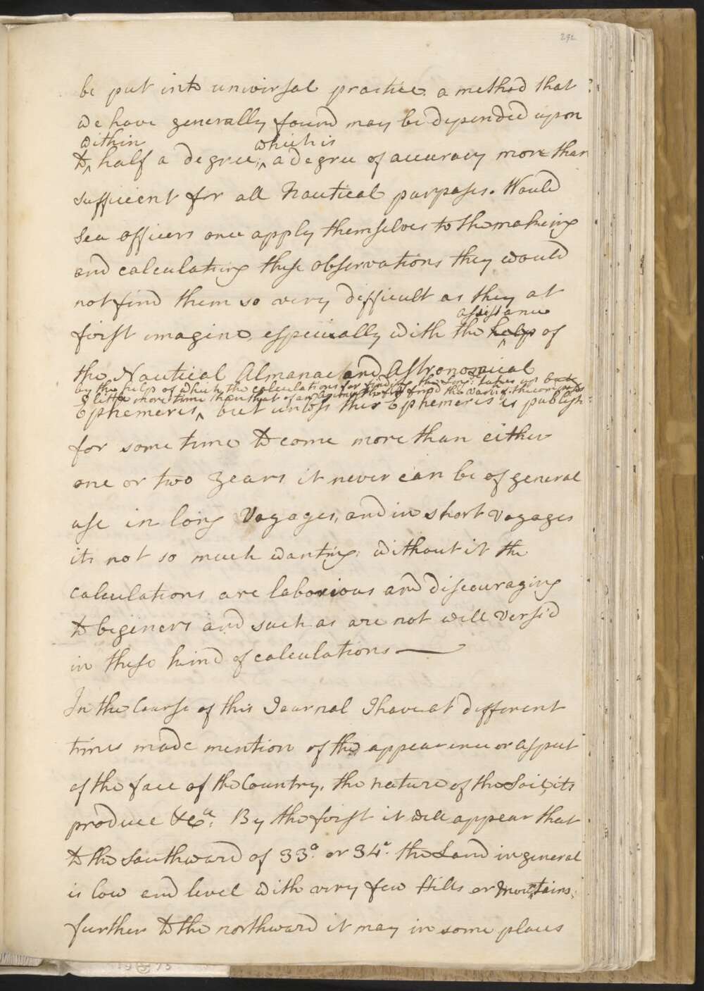
In justice to Mr Green I must say that he was Indefatigable in making and calculating these observations which otherwise must have taken up a great deal of my time, which I could not at all times very well spare. Not only this, but by his Instructions several of the Petty officers can make and Calculate these observations almost as well as himself: it is only by such means that this method of finding the Longitude at Sea can be put into universal practice, a method that we have generally found may be depended upon to within half a degree; which is a degree of accuracy more than Sufficient for all Nautical purposes. Would Sea officers once apply themselves to the makeing and calculating these observations they would not find them so very difficult as they at first imagine, especially with the help assistance of the Nautical Almanac and Astronomical Ephemeris by the help of which the calculations for finding the Longde takes up but little more time than that of an Azimuth for find the Varin of the compass but unless this Ephemeris is publishd for some time to come more than either one or two Years it can never be of general use in long Voyages, and in short Voyages its not so much wanting; without it the Calculations are laborious and discouraging to beginers and such as are not well Vers'd in these kind of calculations —
[At this point in the manuscript, Cook commences his general description of New South Wales]
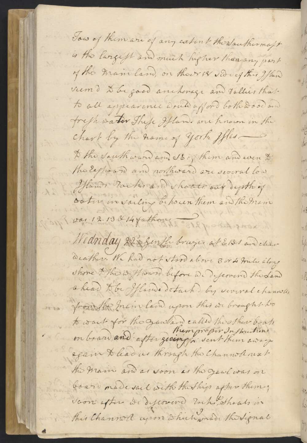
Wednesday 22d Gentle breezes at EBS and clear weather. We had not stood above 3 or 4 Miles along shore to the westward. before we discover'd the Land ahead to be Islands detach'd by several channells from the Main land, upon this we brought too to wait for the yawl and called the other boats on board, and after giving them proper Instructions sent them away again to lead us through the Channell next the Main, and as soon as the yawl was on board made sail with the Ship after them;
soon after we discoverd Rocks, & shoals in this Channell upon which I made the Signal for the boats to lead through the next Channel to the Northward laying between the Islands which they accordingly did we following with the Ship and had not less than 5 fathom water and this was in the narrowest part of the Channell which was about a Mile and a half broad from Island to Island.
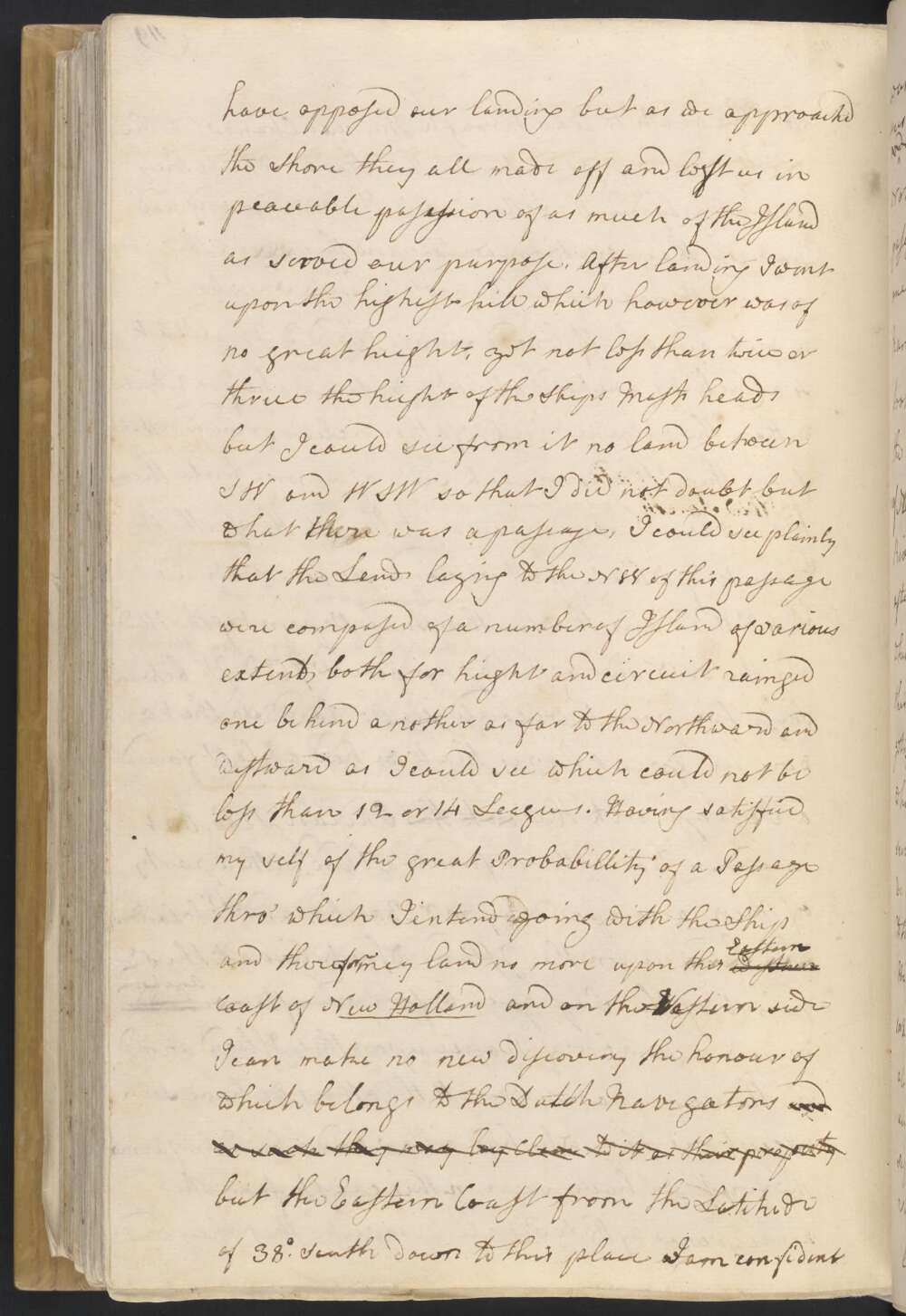
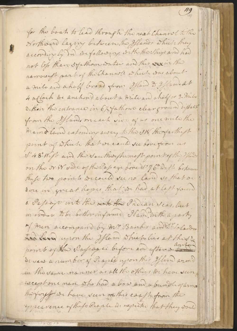
At 4 oClock we anchor'd about a Mile and a half or 2 Miles within the entrance in 6½ fathom clear ground distant from the Islands on each side of us one mile, the Maind land extending away to the SW, the farthest point of which that we could see bore from us St 48° West and the South-wester-most point of the Islands on the NW side of the Passage bore St 76° West between these two points we could see no land so that we were in great hopes that we had at last found out a Passage into the into the Indian seas, but in order to be better informd I landed with a party of Men accompan'd by Mr Banks and Dr Solander and land upon the Island which lies at the SE point of the Passage:
before and after we landed Anchor'd we saw a number of People upon this Island arm'd in the same — manner as all the others we have seen except one man who had a bow and a bundle of Arrows the first we have seen on this coast. from the appearence of these People we expected they would have opposed our landing but as we approached the Shore they all made off and left us in peaceable posession of as much of the Island as served our purpose.
After landing I went upon the highest hill which however was of no great height, yet not less than twice or thrice the height of the Ships Mast heads but I could see from it no land between SW and WSW so that I did not doubt but there was a passage, I could see plainly that the Lands laying to the NW of this passage were composed of a number of Island of various extent both for height and circuit rainged one be hind a nother as far to the Northward and Westward as I could see which could not be less than 12 or 14 Leagues.
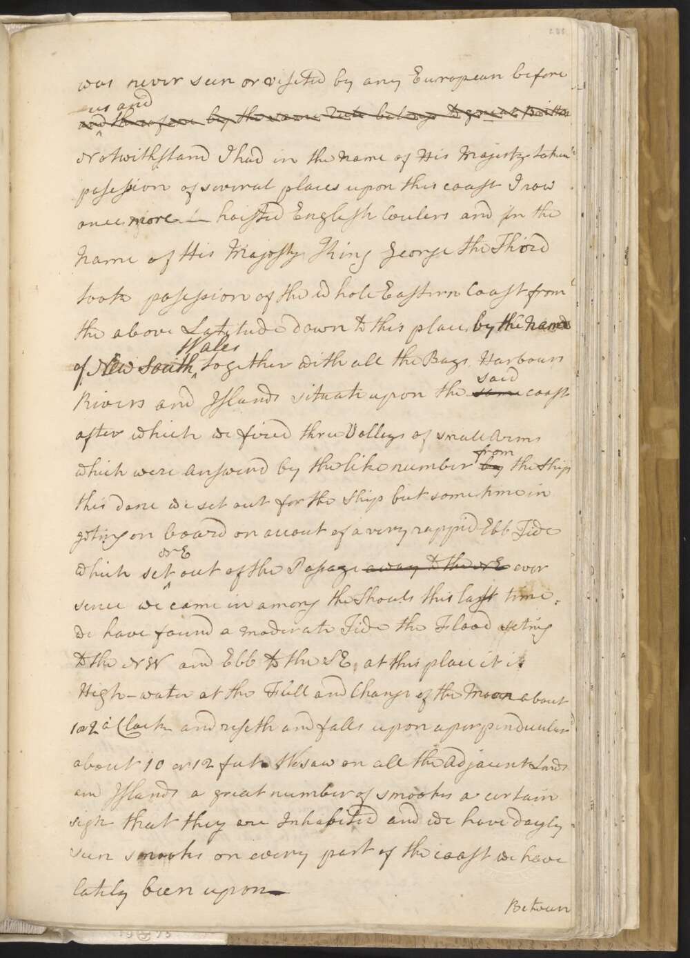
Having satisfied myself of the great Probabillity of a Passage, thro' which I intend going with the Ship and therefor may land no more upon this Western Eastern coast of New Holland and on the Western side I can make no new discovery the honour of which belongs to the Dutch Navigators and as such they may lay claim to it as their property but the Eastern Coast from the Latitude of 38° South down to this place I am confident was never seen or viseted by any European before us and therefore by the same Rule belongs to great Brittan Notwithstand I had in the Name of his Majesty taken posession of several places upon this coast I now once more hoisted English Coulers and in the Name of His Majesty King George the Third took posession of the whole Eastern Coast from the above Latitude down to this place by the Name of New South Wales together with all the Bays, Harbours Rivers and Islands situate upon the same said coast after which we fired three Volleys of small Arms which were Answerd by the like number by from the Ship
this done we set out for the Ship but were some time in geting on board on accout of a very rappid Ebb Tide which set NE out of the Passage away to the NE ever sence we came in among the Shoals this last time we have found a Moderate Tide the Flood seting to the NW and Ebb to the SE. at this place it is High-water at the Full and Change of the Moon about 1 or 2 o'Clock and riseth and falls upon a perpendicular about 10 or 12 feet.
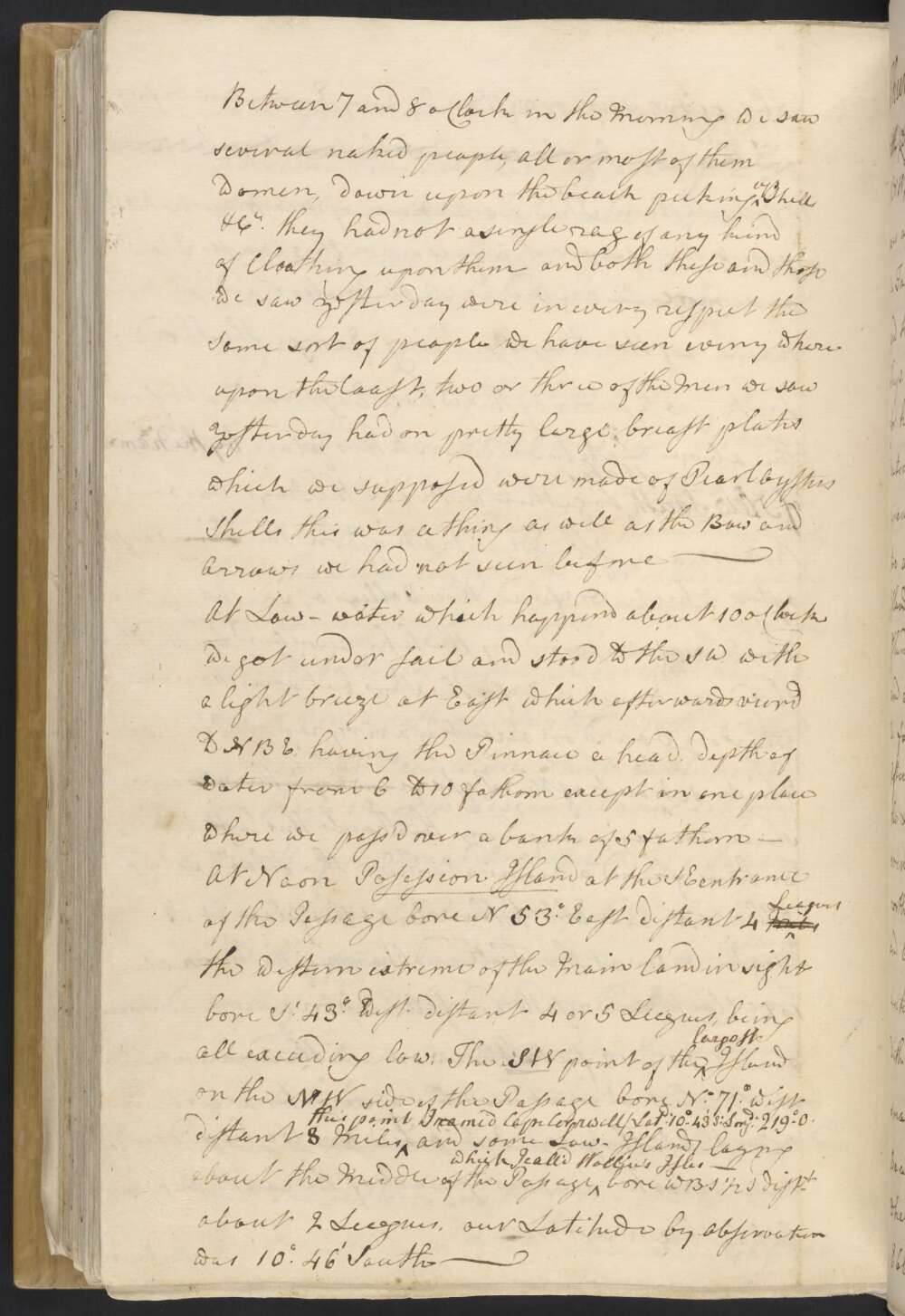
We saw on all the Adjacent Lands and Islands a great number of smooks a certain sign that they are Inhabited and we have dayly seen smooks on every part of the coast we have lately been upon — Between 7 and 8 oClock in the Morning we saw several naked people, all or most of them women, down upon the beach picking up Shells, &Ca they had not a single rag of any kind of Cloathing upon them and both these and those we saw yesterday were in every respect the Same sort of people we have seen every where upon the Coast; two or three of the Men we saw Yesterday had on pretty large breast plates which we supposed were made of Pearl Oysters Shells this was a thing as well as the Bow and Arrows we had not seen before —
At Low-water which happend about 10 oClock we got under sail and stood to the SW with a light breeze at East which afterwards veerd to NBE, having the Pinnace a head, depth of water from 6 to 10 fathom except in one place where we pass'd over a bank of 5 fathom —
At Noon Posession Island at the SE entrance of the Passage bore N 53° East distant 4 Miles Leagues the western extreme of the Main land in sight bore St 43° West distant 4 or 5 Leagues, being all exceeding low, The SW point of the largest Island on the NW side of the Passage bore No 71° West distant 8 Miles this point I named Cape Cornwell / Latd 10°..43' S: Longde 219°..0 and some Low Islands laying about the Middle of the Passage which I call'd Wallice's Isles — bore WBS ½ S distt about 2 Leagues, our Latitude by Observation was 10°.46' South —
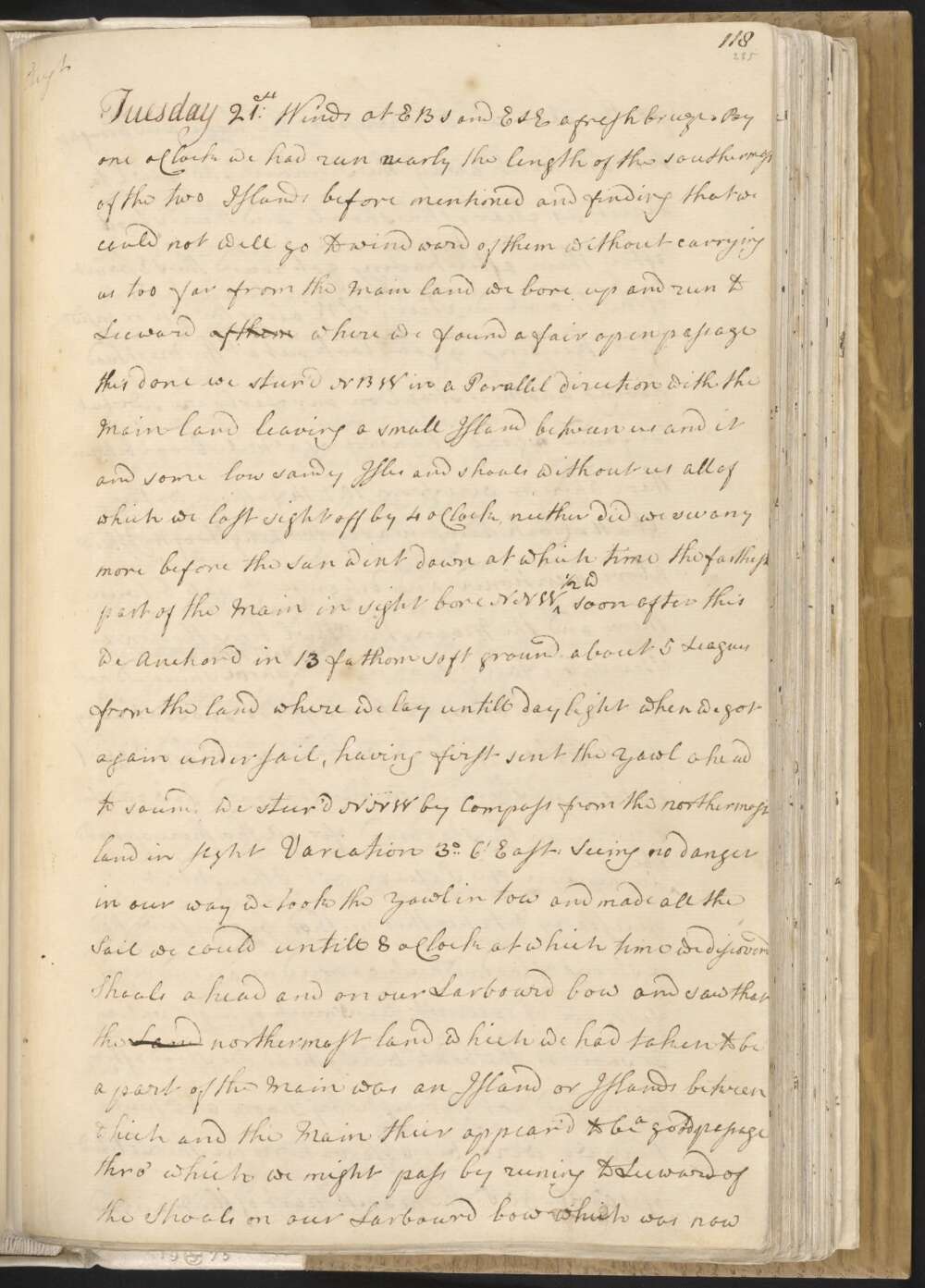
Tuesday 21st. Winds at EBS and ESE a fresh breeze. By one oClock we had run nearly the length of the southermost of the two Islands before mentioned and finding that we could not well go to windward of them without carrying us too far from the Main land we bore up and run to Leeward of them where we found a fair open passage this done we steer'd NBW in a Parallel direction with the Main land leaving a small Island between us and it and some low sandy Isles and shoals without us all of which we lost sight of by 4 oClock, neither did we see any more before the sun went down at which time the farthest part of the Main in sight bore NNW ½ W
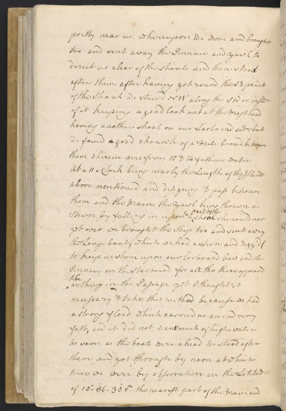
soon after this we Anchord in 13 fathom soft ground about 5 Leagues from the land where we lay untill day light when we got again under sail, having first sent the Yawl ahead to sound, we steerd NNW by Compass from the northermost land in sight Variation 3°..6' East: Seeing no danger in our way we took the Yawl in tow and made all the Sail we could untill 8 oClock at which time we discoverd Shoals ahead and on our Larboard bow and saw that the Land northermost land which we had taken to be a part of the Main was an Island or Islands between which and the Main their appeared to be a good passage thro' which we might pass by runing to Leeward of the Shoals on our Larboard bow which was now pretty near us. whereupon we wore and brought too and sent away the Pinnace and yawl to direct us clear of the shoals and then stood after them.
after having got round the SE point of the Shoal we steerd NW along the SW or inside of it keeping a good look out at the Mast head having another shoal on our Larboard side, but we found a good channell of a Mile broad between them wherein were from 10 to 14 fathoms water At 11 oClock being nearly the Length of the Islands above mentioned and designing to pass between them and the Main, the Yawl being thrown a Stern by falling in upon a part of the shoal she could not get over we brought the Ship too and sent away the Long-boat / which we had a stern and rigg'd / to keep in shore upon our larboard bow and the Pinnace on the Starboard for all tho there appear'd to be nothing in the Passage yet I thought it necessary to take this method be cause we had a strong flood which carried us an end very fast, and it did not want much of high-water
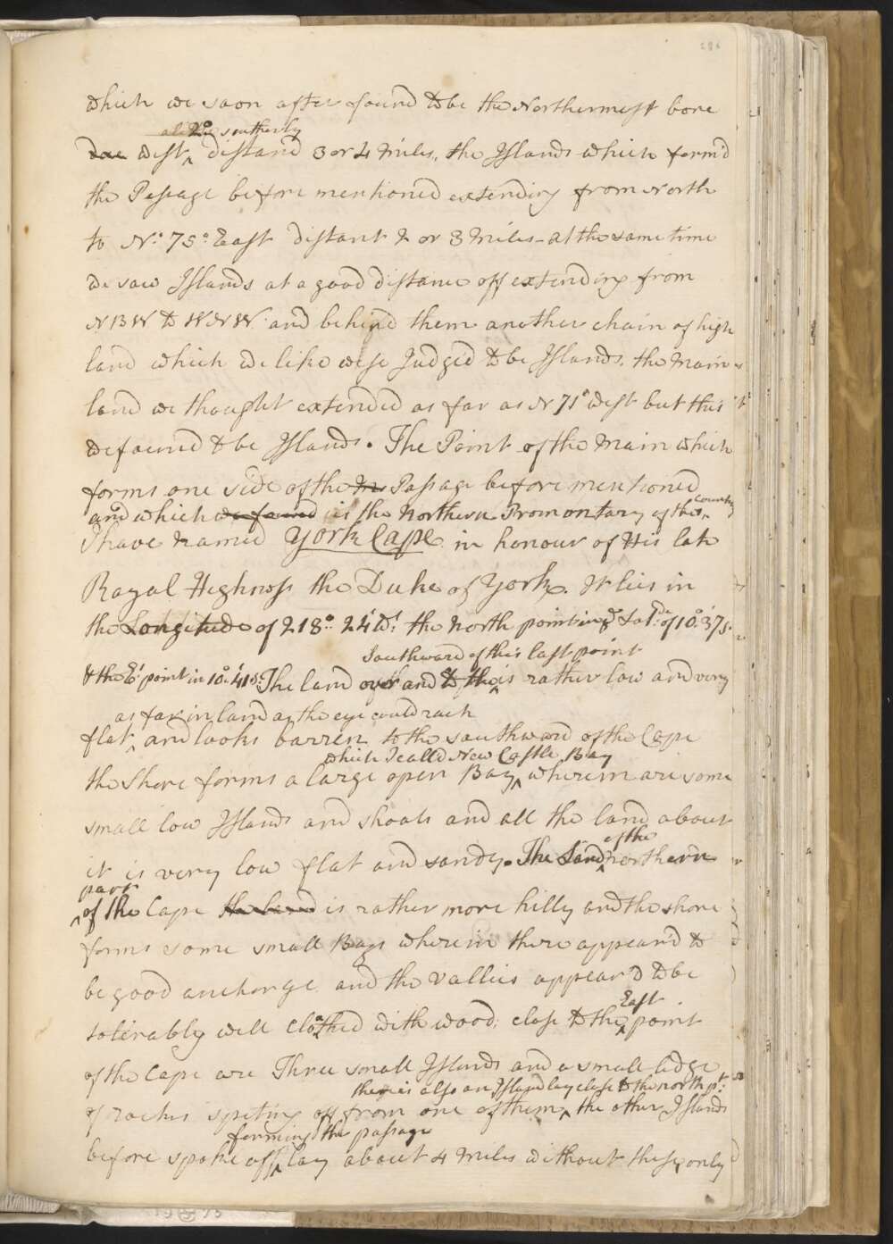
As soon as the boats were ahead we stood after them and got through by noon at which time we were by observation in the Latitude of 10°..36'..30" St the nearest part of the Main, and which we soon after found to be the Northermost bore due west a little 2° southerly distand 3 or 4 Miles, the Islands which form'd the Passage before mentioned extending from North to N. 75° East distant 2 or 3 Miles —
At the same time we saw Islands at a good distance off extending from NBW to WNW and behind them another chain of high land which we like wise Judge'd to be Islands, the Main land we thought extended as far as N 71° west but this we found to be Islands. The point of the Main which forms one side of the M Passage before mentioned and which we found is the Northern Promontary of this Country I have named York Cape in honour of His late Royal Highness the Duke of York. It lies in the Longitude of 218°..24' Wt the North point in ye Latde of 10°.37' S. & the Et point in 10°..41' S.
The land over and to the Southward of this last point is rather low and very flat as far in land as the eye could rach and looks barren to the southward of the Cape the Shore forms a large open Bay which I called New Castle Bay wherein are some small low Islands and shoals and all the land about it is very low flat and sandy.
The Land of the northern part of the Cape the land is rather more hilly and the shore forms some small Bays wherein there appear'd to be good anchorage, and the Vallies appear'd to be tolerably well Cloathed with wood; close to the East point of the Cape are Three small Islands and a small ledge of rocks spiting off from one of them there is also an Island lay close to the north Pt the other Islands before spoke off forming the passage lay about 4 Miles without these, only Tow of them are of any extent, the Southermost is the largist and much higher than any part of the Main land, on the NW side of this Island seem'd to be good anchorage and Vallies that to all appearence would afford both wood and fresh water These Isles are known in the Chart by the name of York Isles —
to the Southward and SE of them and even to the Eastward and northward are several low Islands Rocks and shoals — our depth of water in sailing between them and the Main was 12. 13 & 14 fathoms —
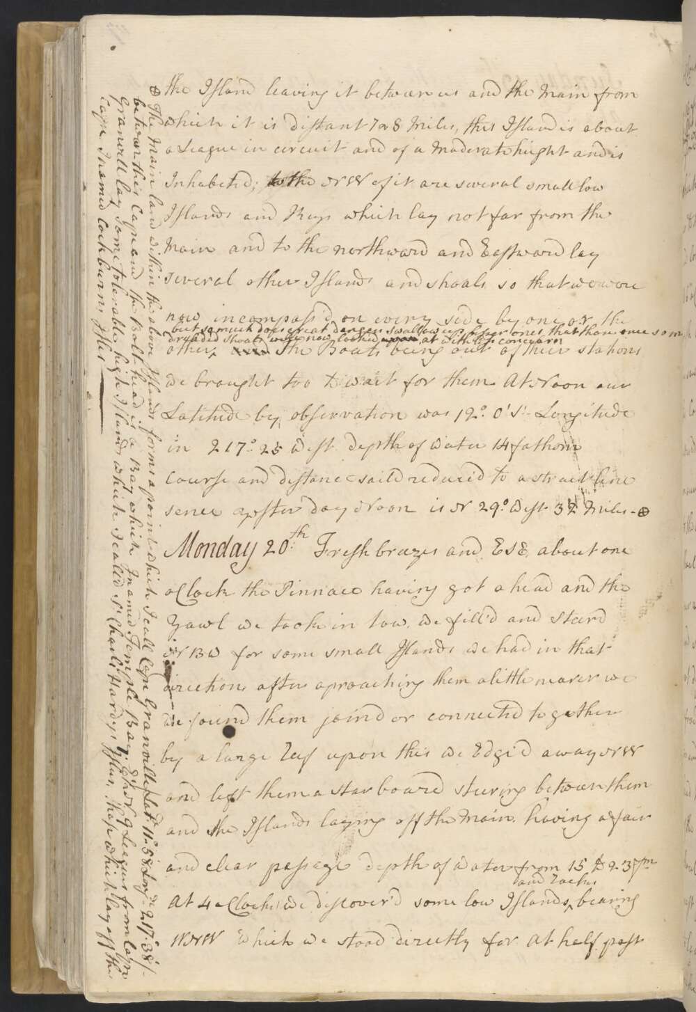
Monday 20th Fresh breezes and ESE, about one oClock the Pinnace having got ahead and the Yawl we took in tow, we fill'd and Steerd NBW for some small Islands we had in that direction, after aproaching them a little nearer we found them joind or connected together by a large Reef upon this we Edge'd away NW and left them a starboard steering between them and the Islands laying off the Main, having a fair and clear passage depth of water from 15 to 23 fm
At 4 oClock we discover'd some low Islands and Rocks bearing WNW which we stood directly for. At half past 6 oClock we Anchord on the NE side of the northermost in 16 fathom water distant from the Island one mile The Isles lay NW 4 Leagues from C. Granville, on these Isles we saw a good many Birds which occasioned my calling them Bird Isles —
Before and at sun set we could see the Main land which appear'd all very low and sandy extend as far to the Northward as NWBN, and some Shoals, Keys and low sandy Isles away to the NE of us—
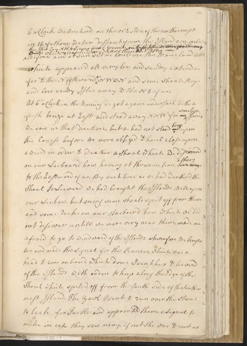
At 6 oClock in the Morning we got again under sail with a fresh breeze at East and stood away NNW for an some low Islands we saw in that diretion, but we had not stood on long upon this Course before we were obliged to haul close upon a wind in order to weather a Shoal which we discover'd on our Larboard bow, having at the same time two larg others to the Eastward of us,e
By such time as we had weather'd the Shoal to Leeward we had brought the Islands well upon our Lee-bow, but seeing some shoals spit off from them and some Rocks on our starboard bow which we did not discover untill we were very near them, made me afraid to go to windward of the Islands, wherefore we brought too, and made the Signal for the Pinnace, which was a head to come on board, which done I sent her to leeward of the Islands with orders to keep along the Edge of the Shoal which spited off from the South side of the Southermost Island.
The Yawl I sent to run over the Shoal to look for Turtle and appointed them a Signal to make in case they saw many, if not she was to meet us on the other side of the Island. As soon as the Pinnace had got a proper distance from us we wore and stood after her and run to Leeward of the Island where we took the Yawl in tow — she having seen only one small Turtle and therefore made no stay upon the Shoal
Upon this Island which is only a small spot of Sand with some trees upon it, we saw a good many hutts or habitations of the Natives which we supposed comes over from the Main to these Islds / from which they are distant about 5 Leagues / to Catch Turtle at the time these Animals come a Shore to lay their Eggs.
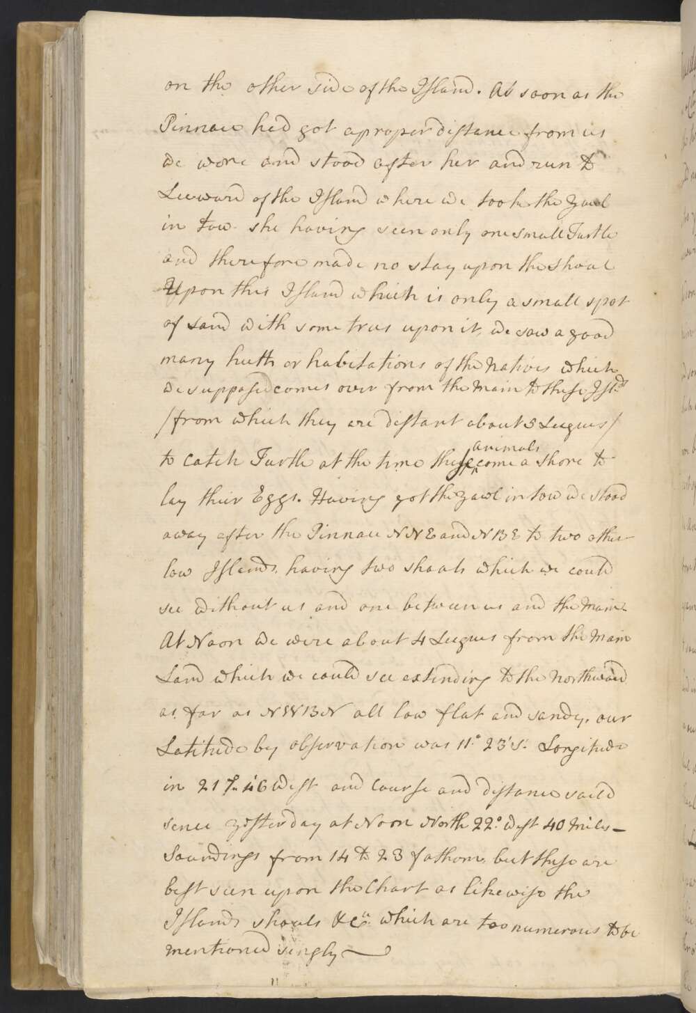
Having got the yawl in tow we stood away after the Pinnace NNE and NBE to two other low Islands, having two shoals which we could see without us and one between us and the Main.
At Noon we were about 4 Leagues from the Main Land which we could see extending to the Northward as far as NWBN all low flat and sandy, our Latitude by observation was 11° 23' St Longitude in 217°..46' West and Course and distance saild sence yesterday at Noon North 22° West 40 Miles — Soundings from 14 to 23 fathom, but these are best seen upon the Chart as likewise the Islands shoals &Ca which are too numerous to be mentioned singly —
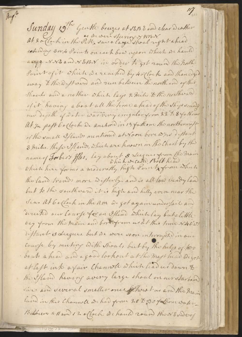
Sunday 19th Gentle breezes at SEBE and clear weather At 2 oClock in the PM as we were steering NWBN saw a large shoal right ahead extending 3 or 4 Points on each bow upon which we hauld up NNE and NEBN in order to get round the North Point of it which we reached by 4 oClock and than edged away to the westward and run between the north end of this shoals and a nother which lays 2 miles to the northward of it having a boat all the time ahead of the Ship sound.g our depth of water was very erregular from 22 to 8 fathoms
At ½ past 6 oClock we Anchor'd in 13 fathom, the northermost of the small Islands mentioned at Noon bore W ½ S distant 3 Miles, these Islands, which are known in the Chart by the name of Forbes's Isles, lay about 5 Leagues from the Main which here forms a moderatly high Point which we call'd Bolt head from which the land trends more westerly and is all low lSandy land but to the southward it is high and hilly even near the Sea.
At 6 oClock in the AM we got again under sail and directed our Course for an Island which lay but a little way from the Main and bore from us at this time N. 40° Wt distant 5 Leagues, but we were soon interrupted in our course by meeting with Shoals, but by the help of two Boats ahead and a good lookout at the Mast head we got at last into a fair Channel which lead us down to the Island having a very large shoal on our starboard side and several smaller ones betwixt us and the Main land, in this Channell we had from 20 to 30 fathom water —
Between a 11 and 12 oClock we hauld round the NE side of the Island leaving it between us and the Main from which it is distant 7 or 8 Miles, this Island is about a League in circuit and of a Moderate height and is Inhabited; to the NW of it are several small low Islands and Keys which lay not far from the Main and to the northward and Eastward lay several other Islands and shoals so that we were now incompass'd on every side by one or the other, but so much does great danger Swallow up lesser ones that these once so much dreaded Shoals were now looke'd upon at with less concearn
The Boats being out of their stations we brought too to wait for them. At Noon our Latitude by observation was 12°.0' St Longitude in 217°..25 West depth of Water 14 fathom Course and distant saild reduce'd to a strait line sence yesterday Noon is N 29° West 32 Miles.†
† The Main land within the above Islands forms a point which I call Cape Grenville / Latde 11°..58', Longde 217°.38' / between this Cape and the Bolt head is a Bay which I named Temple Bay. E ½ N 9 Leagues from Cape Granvill lay some tolerable high Islands which I call'd Sr Charles Hardys Isles, those which lay off the Cape I named Cockburns Isles
Saturday 18th Gentle breezes at East and ESE — At 4 oClock in the PM the boats return'd from the reef with about 240 pounds of the meat of shell fish most of Cockles, some of which are as large as 2 Men can move and contain about 20 lbs of good meat
At 6 oClock in the Morning we got under sail and Stood away to the NW having two boats to derict us — our soundings were very erregular from 10 to 27 fathom varying 5 or 6 fathom almost every cast of the lead — A little before noon we passed a low small Sandy Isle which we left on our starboard side at the distance of 2 Miles, Mr Banks landed upon it and shott several small birds, call'd Nodies —
At Noon our Latitude was 12°..28 being about 4 or 5 Leagues from the Main which extended from SBW to N 71° Wt and some Small Islands extending from N. 40° Wt to 54° Wt between us and the Main or outer Reef seen from the Mast head a way to the NE —
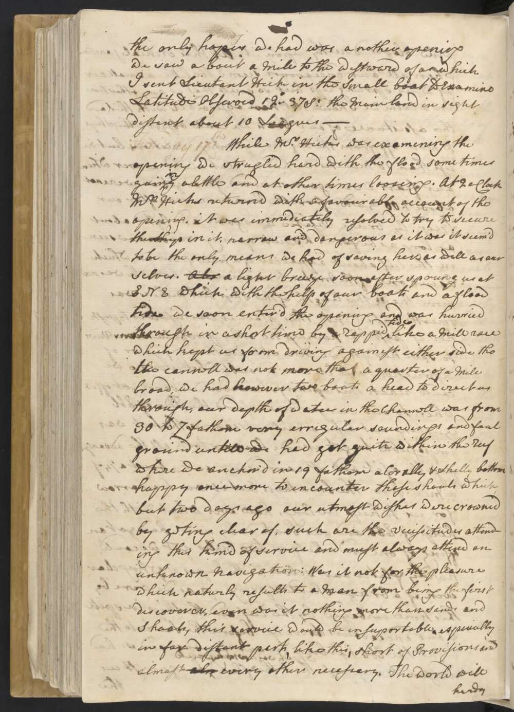
Friday 17th While Mr Hicks was examining the opening we strugled hard with the flood some time gaining a little and at other times looseing. At 2 oClock Mr Hicks returned with a favourable account of the opening. it was immidiately resolved to try to secure the Ship in it, narrow and dangerous as it was it seem'd to be the only means we had of saving her as well as our selves.
Abo a light breeze soon after sprung up at ENE which with the help of our boats and a flood tide we soon enter'd the opening and was hurried thro' in a short time by a rappid tide like a Mill race which kept us from driving againest either side tho the cannel was not more than a quarter of a Mile broad, we had however two boats ahead of us to direct us through, our depth of water in the Channell was from 30 to 7 fathom very erregular soundings and foul ground untill we had got quite within the Reef where we anchor'd in 19 fathom a Corally & Shelly bottom happy once more to incounter those shoals which but two days ago our utmost wishes were crowned by getting clear of, such are the vicissitudes attending this kind of service and must always attend an unknown Navigation:
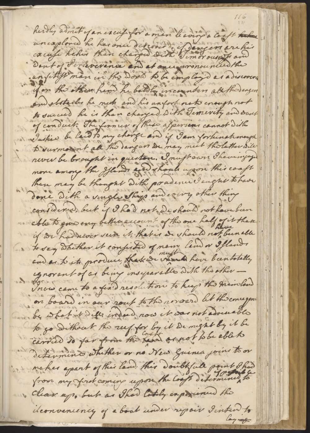
Was it not from the pleasure which naturly results to a Man from being the first discoverer, even was it nothing more than sands and Shoals, this service would be insuportable, especialy in far distant parts, like this, short of Provisions and almost also every other necessary. The world will hardly admit of an excuse for a man leaving a Coast he has unexplored he has once discover'd, if dangers are his excuse he is than charged with Timorousness and want of Perseverance and at once pronounced the unfitest man in the world to be employ'd as a discoverer if on the other hand he boldly incounters all the dangers and obstacles he meets and his unfortunate enough not to succeed he is than charged with Temerity and want of conduct.
The former of these aspersins cannot with Justice be laid to my charge and if I am fortunate enough to surmount all the dangers we may meet the latter will never be brought in question. I must own I have ingaged more among the Islands and shoals upon this Coast than may be thought with prudence I ought to have done with a single Ship and every other thing considered, but if I had not I should not have been able to give any better account of the one half of it than if we had never seen it, that is we should not have been able to say wether it consisted of main land or Islands and as to its produce, that we should must have been totally ignorant of as being inseparable with the other —
I now came to a fix'd resolution to keep the Main land on board in our rout to the norward let the consequence be what it will, indeed now it was not adviseable to go without the reef, for by it we might be carried so far from the land Coast as not to be able to determine whether or no New Guinea joins to or makes a part of this land; this doubtfull point I had from my first coming upon the Coast determined if possible to clear up, but as I had lately experienced the ilconveniency of a boat under repair I intend to laying fast with the Ship tomorrow untill to have the Pinnace repaired and as I had no employ'd for the other boats I sent them all out in the morning to the reef to get such refreshments as they could find —
Found the Variation by the Ampd and Azth to be 4°..9' East At noon Latitude observed 12°-38' St Longitude in 216°..45' Wt the Main land extending from N 66° West to SWBS, distant off the nearest part 8 or 9 Leagues, the opening we came in by, which I have named Provdential Channell, bore ENE distant 10 or 12 Miles — On the Main land within us was a pretty high Promontory which I call'd Cape Weymouth, on the north side of the Cape is a Bay known by the same name / Latitude 12°..42', Longitude 217°..15' Wt / —
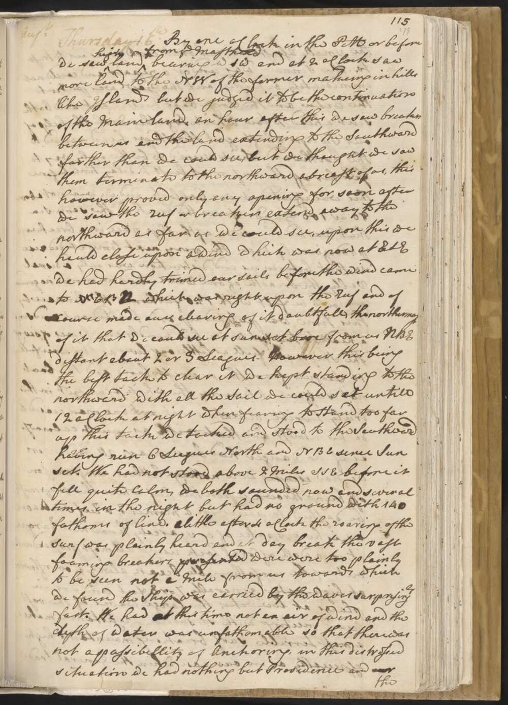
Thursday 16 By one oClock in the PM or before we saw high land from ye Masthead bearing WSW and at 2 oClock saw more land to the NW of the former makeing in hills like Islands but we judged it to be the continuation of the Main land. An hour after this we saw breakers between us and the land extending away to the Southward farther than we could see, but we thought we saw them terminate to the northward abreast of us, this however proved only any opening for soon after we saw the Reef or breakers extend away to the northward as far as we could see, upon this we hauld close upon awind which was now at ESE we had hardly trimed our sails before the wind came to NEBEN which was right upon the Reef and of course made our clearing of it doubtfull, the northernmost of it that we could see at sun set bore from us NBE distant about 2 or 3 Leagues —
hHowever this being the best tack to clear it we kept standing to the northward with all the Sail we could set untill 12 oClock at night when fearing to Stand too far up this tack we tacked and stood to the Southward having run 6 Leagues North and NBE sence Sun set. We had not stood above 2 Miles to the SSE before it fell quite Calm, we both sounded now and several times in the night but had no ground with 140 fathoms of line. A little after 4 oClock the roaring of the Surf was plainly heard and at day break the vast foaming breakers presented were too plainly to be seen not a Mile from us towards which we found the Ship was carried by the waves surprisingly fast.
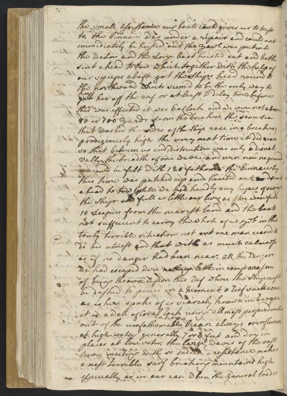
We had at this time not an air of wind and the depth of water was unfathomable so that there was not a possibility of Anchoring, in this distressed situation we had nothing but Providence and our the small Assistance our boats could give us to trust to, the Pinnace was under a repair and could not immediatly be hoisted out, the Yawl was put into the water and the Long-boat hoisted out and both sent ahead to tow which together with the help of our sweeps abaft got the Ships head round to the northward which seem'd to be the only way to yet keep her off the reef or at least to delay time, before this was effected it was 6 oClock and we were not above 80 or 100 Yards from the breakers, the same Sea that washed the sides of the Ship rose in a breaker prodigiously high the very next time it did rise so that between us and distruction was only a dismal Vally the breadth of one wave — and even now no ground could be felt with 120 fathoms the Pinnace was by this time patched up and hoisted out and sent ahead to tow;
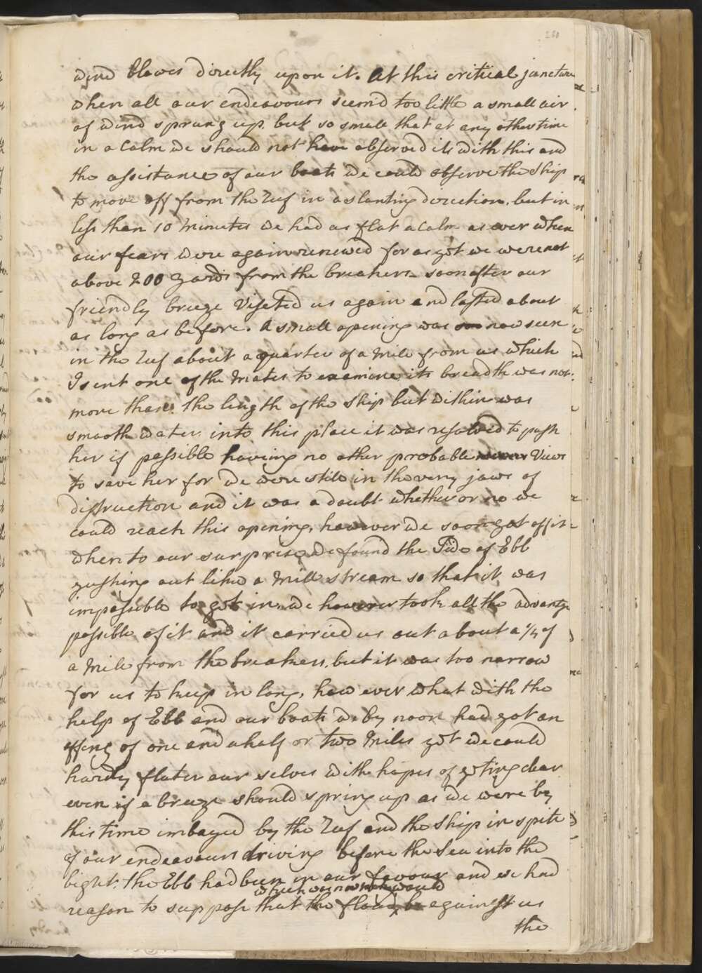
still we had hardly any hopes of saving the Ship and full as little our lives as we were full 10 Leagues from the nearest Land and the boats not sufficient to carry the whole of us yet in this truly terrible situation not one man ceased to do his utmost and that with as much calmness as if no danger had been near. All the dangers we had escaped were nothing little in comparison of being thrown upon this Reef where the Ship must be dashed to peices in a Moment, a Reef such a one as is here spoke of is scarcely known in Europe it is a wall of Coral Rock rising all most perpendicular out of the unfathomable Ocean always overflowen at high-water generally 7 or 8 feet and dry in places at Low-water, the large waves of the vast Ocean meeting with so sudden a resistance makes a most terrible surf breaking mountains high especially as in our case when the general trade wind blowes directly upon it.
At this critical juncture when all our endeavours seem'd too little a small air of wind sprung up, but so small that at any other time in a Calm we should not have observed it, with this and the assistance of our boats we could observe the Ship to move off from the Reef in a slanting direction, but in less than 10 Minutes we had as flat a Calm as ever when our fears were again renewed for as yet we were not above 200 Yards from the breakers —
soon after our friendly breeze Viseted us again and lasted about as long as before. A small opening was see now seen in the Reef about a quarter of a Mile from us which I sent one of the Mates to examine, its breadth was not more than the length of the Ship but within was smooth water, into this place it was resolved to push her if possible haveing no other probable means Views to save her for we were still in the very jaws of distruction and it was a doubt whether or no we could reach this opening, however we soon got off it when to our surprise we found the Tide of Ebb gushing out like a Mill stream so that it was impossible to get in,
we however took all the advantage possible of it and it carried us out about a ¼ of a Mile from the breakers, but it was too narrow for us to keep in long, how ever what with the help of Ebb and our boats we by noon had got an offing of one and a half or two Miles yet we could hardly flater our selves with hopes of geting clear even if a breeze should spring up as we were by this time imbayed by the Reef and the Ship in spite of our endeavours driving before the Sea into the bight, the Ebb had been in our favour and we had reason to suppose the flood which was now making would be againest us the only hopes we had was another opening we saw a bout a Mile to the Westward of us which I sent Lieutant Hick in the Small boat to examine Latitude Observed 12°..37 St the Main land in sight distant about 10 Leagues —
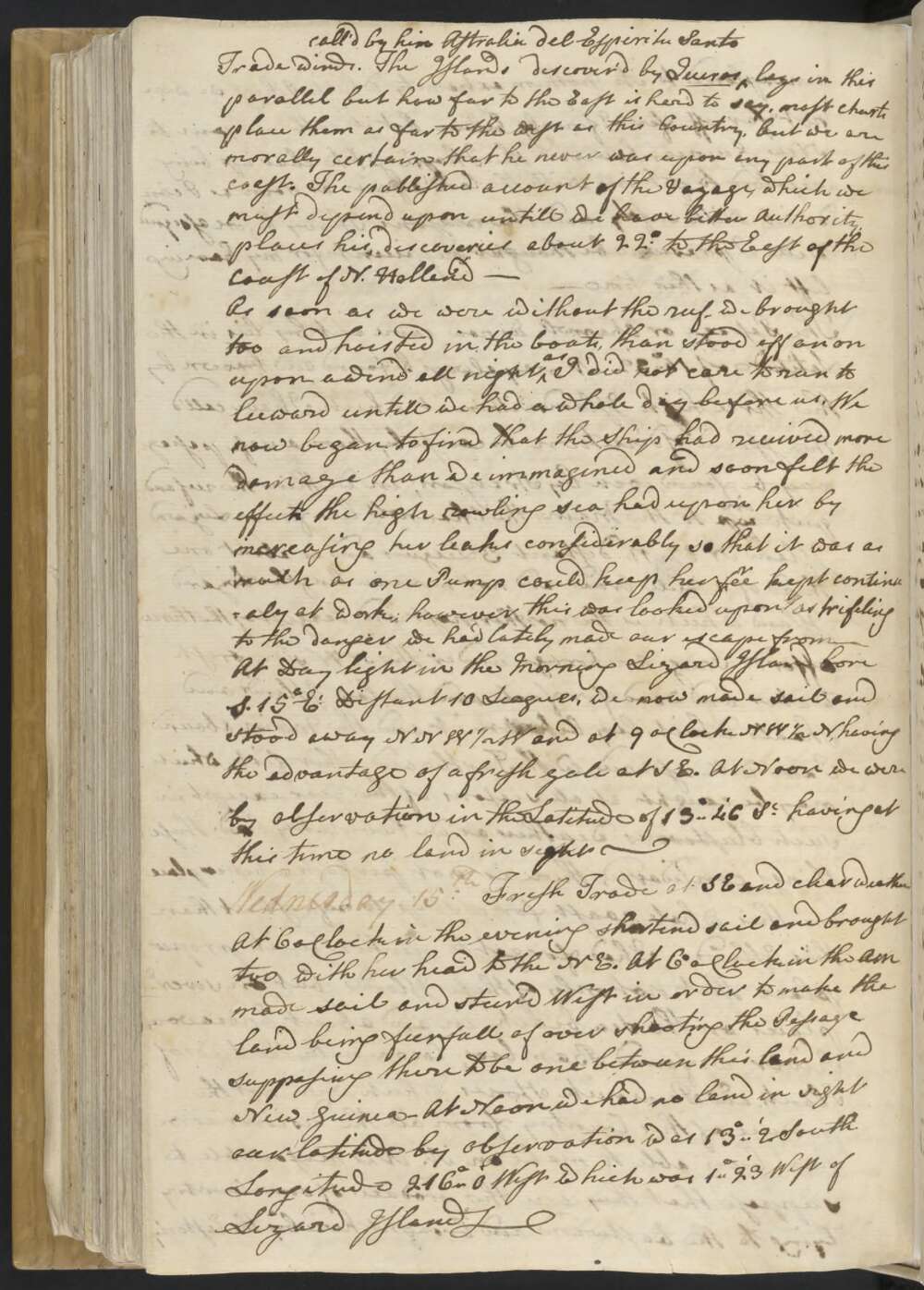
Wednesday 15th Fresh Trade at SE and clear weather At 6 oClock in the evening shortned sail and brought too with her head to the NE. At 6 oClock in the AM made sail and steer'd West in order to make the land being feerful of over shooting the Passage supposeing there to be one between this land and New Guinea — At Noon we had no land in sight our latitude by observation was 13°..2' South Longitude 216°..0' West which was 1°..23' to the West of Lizard Island —
Tuesday 14th Winds at SE a steady fresh gale By 2 oClock we just fetched to windward of one of the Channels in the outer Reef I had seen from the Island, we now tacked and made a short trip to the SW while the Master in the Pinnace examine'd the channell, he soon made the Signal for the Ship to follow which we accordingly did and in a short time got safe out, we had no sooner got without the breakers than we had no ground with 150 fathom of line and found a well growen Sea rowling in from the SE certain signs that nither land nor shoals were in our neighbourhood in that direction which made us quite easy at being free'd from fears of Shoals &Ca —
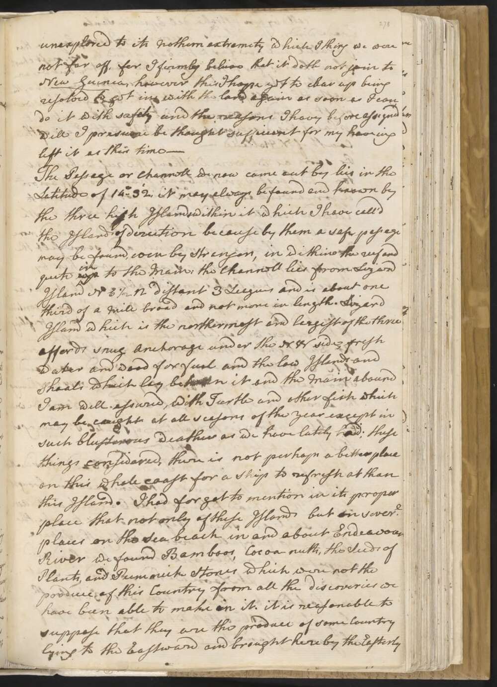
after having been intangled among them more or less ever sence the 26th of May, in which time we have saild 360 Leagues without ever having a Man out of the cheans heaving the Lead when the Ship was under way, a circumstance that I dare say never happen'd to any ship before and yet it was absolutely necessary. It was with great regret I was obliged to quit this coast unexplored to its Nothern extremity which I think we were not far off, for I firmly believe that it doth not join to New Guinea, however this I hope yet to clear up being resolved to get in with the land again as soon as I can do it with safety and the reasons I have before assigned will I presume be thought sufficient for my haveing left it at this time —
The Passage or Channell we now came out by lies in the Latitude of 14°..32', it may always be found and known by the three high Islands within it which I have called the Islands of direction because by them a safe passage may be found, even by Strangers, in within the reef and quite up in to the Main; the Channell lies from Lizard Island NE ½ N distant 3 Leagues and is about one third of a Mile broad and not more in length.
Lizard Island which is the northermost and largest of the three affords snug Anchorage under the NW side, fresh water and wood for fuel and the low Islands and Shoals which lay between it and the Main abound I am well-assured, with Turtle and other fish which may be caught at all seasons of the year except in such blusterous weather as we have lately had; these things considered, there is not perhaps a better place on this whole coast for a Ship to refresh at than this Island.
I had forgot to mention in its proper place that not only of these Islands but in severl places on the Sea beach in and about Endeavour River we found Bamboos, Cocoa-nutts, the Seeds of Plants, and Pummick Stones which were not the produce of this Country from all the discoveries we have been able to make oin it. it is reasonable to suppose that they are the produce of some Country lying to the Eastward and brought here by the Easterly Trade winds. The Islands discover'd by Quiros call'd by Astralia del Espiritu Santo lays in this parrallel but how far to the East is hard to say, most charts place them as far to the west as this Country, but we are morally certain that he never was upon any part of this coast. The published account of the Voyage, which we must depend upon untill we have better authority, places his discoveries about 22° to the East of the Coast of New Holland —
As soon as we were without the reef we brought too and hoisted in the boats, than stood off an upon a wind all night as I did not care to run to leeward untill we had a whole day before us. We now began to find that the Ship had received more damage than we immagined and soon felt the effect the high rowling sea had upon her by increasing her leaks consideably so that it was as much as one Pump could keep her free kept continualy at work; however this was looked upon as trifleing to the danger we had lately made our escape from —
At Day light in the Morning Lizard Island bore S. 15° Et Distant 10 Leagues, we now made sail and stood away NNW ½ W and at 9 oClock NW ½ N , having the advantage of a fresh gale at SE. At Noon we were by observation in the Latitude of 13°..46' St having at this time no land in sight —
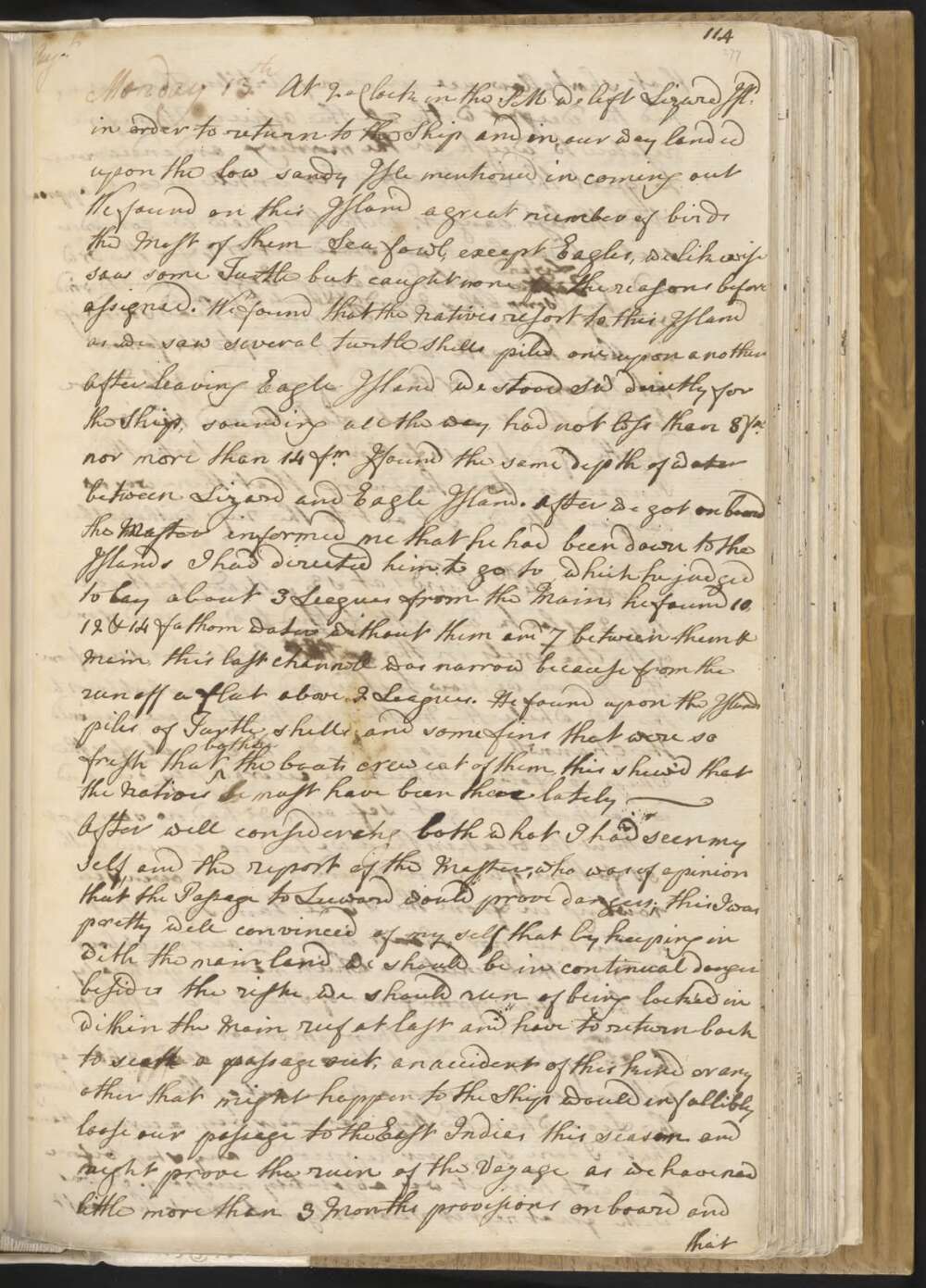
Monday 13th At 2 oClock in the PM we left Lizard Isld in order to return to the Ship and in our way landed upon the low sandy Isle mentioned in coming out We found on this Island a great number of birds the Most of them Sea fowl, except Eagles, we likewise saw some Turtle but caught none for the reasons before assigned. We found that the Natives resort to this Island as we saw several Turtle Shells piled one upon another
After leaving Eagle Island we stood SW directly for the Ship, sounding all the way, and had not less than 8 fm nor more than 14 fm I found the same depth of water between Lizard and Eagle Island. After we got on board the Master informed me that he had been down to the Islands I had directed him to go to which he judged to lay about 3 Leagues from the Main, he found 10, 12 & 14 fathom water without them and 7 between them & Main, this last channell was narrow because from the run off a flat above 2 Leagues. He found upon the Islands piles of Turtle shells and some fins that were so fresh that both the boats crew eat of them, this shew'd that the Natives la must have been there lately —
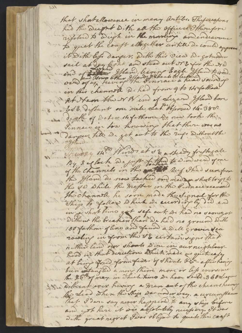
After well considering both what I had seen my self and the report of the Master, who was of opinion that the Passage to Leeward would prove dangers; this I was pretty well convince'd of my self that by keeping in with the main land we should be in continual danger besides the risk we should run in being locke'd in within the Main reef at last and have to return back to seek a passage out, an accident of this kind or any other that might happen to the Ship would infallibly loose our passage to the East Indias this season and might prove the ruin of the Voyage as we have now little more than 3 Months provisions on board and that at short allowance in many Arti[c]les.
These reasons had the weight with all the officers. I therefore resolved to weigh in the morning and endeavour to quet the coast altogether untill we could approach it with less danger, With this View we got under sail at day light and stood out NE for the NW end of Eagle Lizard Island, leaving Eagle Island to windward of us and some other Islands & Shoals to leward having the Pinnace a head sounding in this channell we had from 9 to 14 fathom
At Noon the NW end of Lizard Island bore ESE distant one mile Latde observed 14°..38' St depth of water 14 fathom We now took the Pinnace in tow knowing that there was no danger till we got out to the Reefs without the Island —
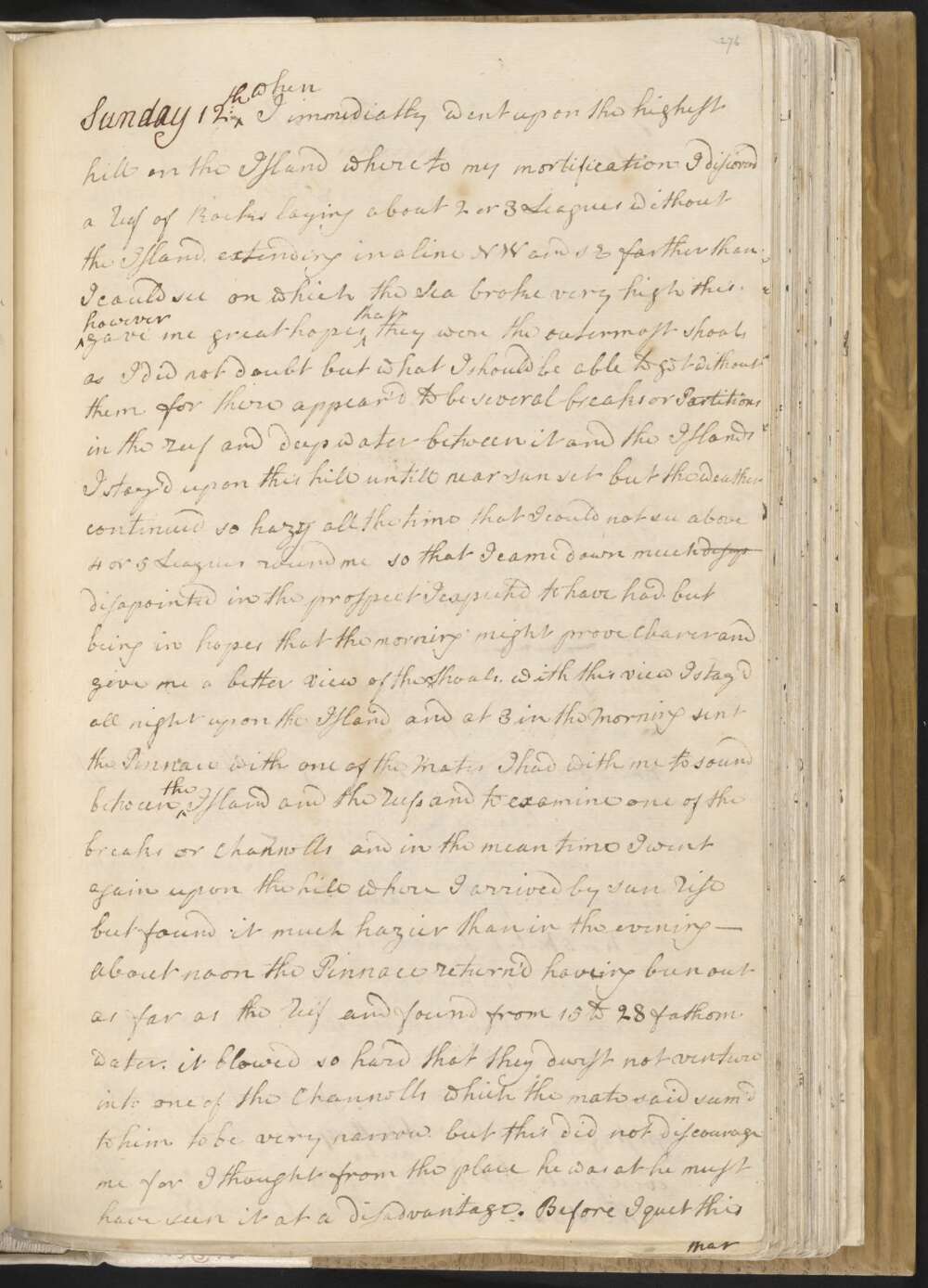
Sunday 12th when I immediatly went upon the highest hill on the Island where to my mortification I discoverd a reef of Rocks laying about 2 or 3 Leagues without the Island, extending in a line NW and SE farther than I could see on which the Sea broke very high this however gave me great hopes that they were the outermost shoals, as I did not doubt but what I should be able to get without them for there appear'd to be several breaks or Partitions in the reef and deep water between it and the Islands I stay'd upon this hill untill near sun set but the weather continued so hazy all the time that I could not see above 4 or 5 Leagues round me so that I came down much disap disapointed in the prospect I expected to have had. but being in hopes the morning might prove clearer and give me a better View of the Shoals.
with this view I stay'd all night upon the Island, and at 3 in the Morning sent the Pinnace with one of the Mates I had with me to sound between the Island and the reefs and to examine one of the breaks or Channells and in the mean time I went again upon the hill where I arrived by sun rise but found it much hazier than in the evening —
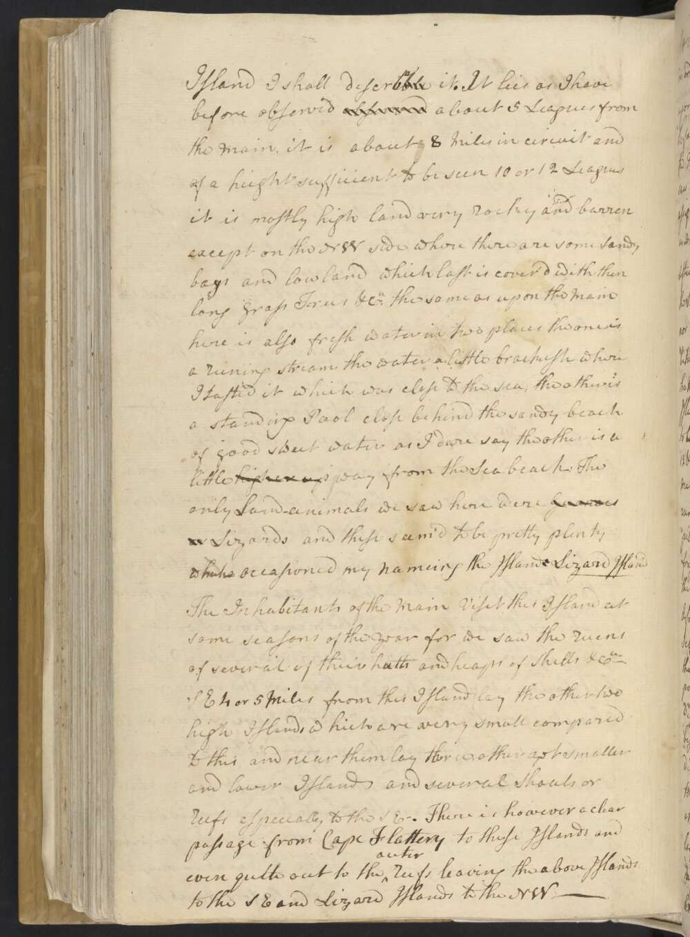
About noon the Pinnace return'd haveing been out as far as the reef and found from 15 to 28 fathoms water. it blowed so hard that they durst not venture into one of the Channells which the Mate said seem'd to him to be very narrow but this did not discourage me for I thought from the place he was at he must have seen it at a disadvantage. Before I quit this Island I shall desirablecribe it.
It lies as I have before observed observed about 5 Leagues from the Main, it is about 8 Miles in circuit and of a height sufficient to be seen 10 or 12 Leagues it is mostly high land very rocky and barren except on the NW side where there are some Sandy bays and low land which last is cover'd with thin long grass Trees, &Ca the same as upon the Main here is also fresh water in two places the one is a runing stream the water a little brackish where I tasted it which was close to the sea, the other is a standing Pool close behind the sandy beach of good sweet water as I dare say the other is a little higher up way from the Sea beach:
The only land-animals we saw here were Guanoes or Lizards and these seem'd to be pretty plenty whenceich occasioned my nameing the Island Lizard Island The inhabitants of the Main Visit this Island at some seasons of the year for we saw the ruens of several of their hutts and heaps of Shells &Ca —
SE 4 or 5 Miles from this Island lay the other two high Islands which are very small compared to this and near them lay three other yet smaller and lower Islands and several Shoals or Reefs especially to the SE. There is however a clear passage from Cape Flattery to these Islands and even quite out to the outer Reefs leaving the above Islands to the SE and Lizard Island to the NW —
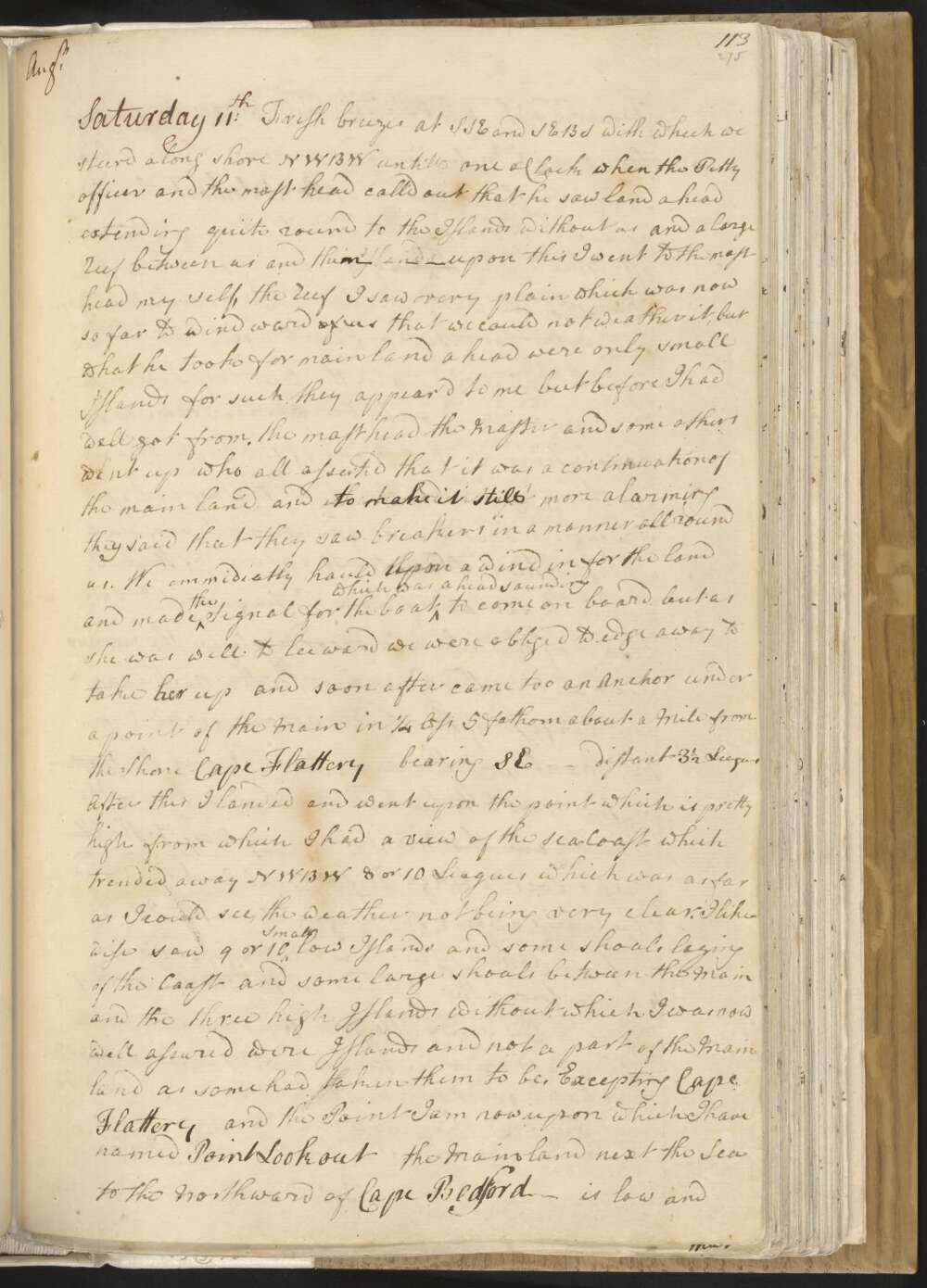
Saturday 11th Fresh breezes at SSE and SEBS with which we steerd along shore NWBW untill one oClock, when the Petty officer at the mast head call'd out that he saw land ahead extending quite round to the Islands without us and a large Reef between us and them Islands — upon this I went to the mast head my self, the Reef I saw very plain which was now so far to wind ward of us that we could not weather it, but what he took for main land ahead were only small Islands, for such they appear'd to me but before I had well got from mast head the Master and some others went up who all asserted that it was a continuation of the main land and to make it still more alarming they said they saw breakers in a manner all round us.
We emmediatly hauld the upon a wind in for the land and made the Signal for the boat which was ahead sounding to come on board, but as she was well to leeward, we were obliged to edge away to take her up and soon after came too an Anchor under a point of the Main in ¼ less 5 fathom about a Mile from the Shore Cape Flattery bearing SE — distant 3½ Leagues After this I landed and went upon the point which is pretty high from which I had a view of the sea-Coast which trended away NWBW 8 or 10 Leagues which was as far as I could see, the weather not being very clear.
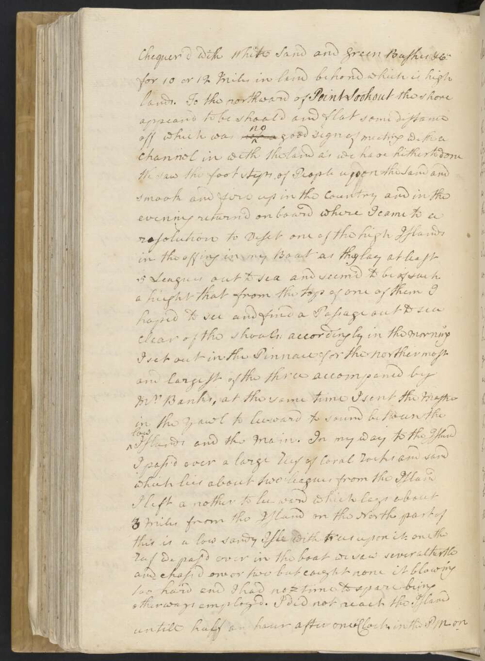
I likewise saw 9 or 10 small low Islands and some shoals laying of the Coast and some large shoals between the Main and the three high Islands without, which I was now well assured were Islands and not a part of the Main land as some had taken them to be, Excepting Cape Flattery and the Point I am now upon which I have named Point Lookout the Mainland next the Sea to the Northward of Cape Bedford — is low and Chequer'd with White Sand and Green Bushes &Ca for 10 or 12 Miles in land behond which is high lands.
To the northward of Point Lookout the shore appeard to be shoald and flat some distance off, which was not no good sign of meeting with a channel in with the land as we have hitherto done We saw the foot steps of People upon the Sand and smook and fire up in the Country and in the evening return'd on board where I came to a resolution to Visit one of the high Islands in the offing in my Boat as they lay at least 5 Leagues out to sea and seem'd to be of such a hieght that from the top of one of them I hoped to see and find a Passage out to sea clear of the shoals;
accordingly in the morning I set out in the Pinnace for the northermost and largest of the three accompaned by Mr Banks, at the same time I sent the Master in the Yawl to lee-ward to sound between the low Islands and the Main. In my way to the Island I pass'd over a large Reef of Coral Rocks and sand which lies about two Leagues from the Island I left a nother to lee ward which lays about 3 Miles from the Island on the North part of this is a low sandy Isle with trees upon it. on the reef we pas'd over in the boat we saw several turtle and chased one or two but caught none it blowing too hard and I had not time to spare being otherways employ'd. I did not reach the Island untill half an hour after one oClock in the PM on
Friday 10th Fresh gales at SSE and SEBS. In the PM the wind fell so as we got up the small bower Anchor and hove in to a whole Cable on the best bower. At 3 oClock in the morning we got up the lower yards and at 7 weigh'd and stood in for the land / intending to seek a passage along shore to the northward / having a Boat ahead sounding, depth of water as we run in from 19 to 12 fathom:
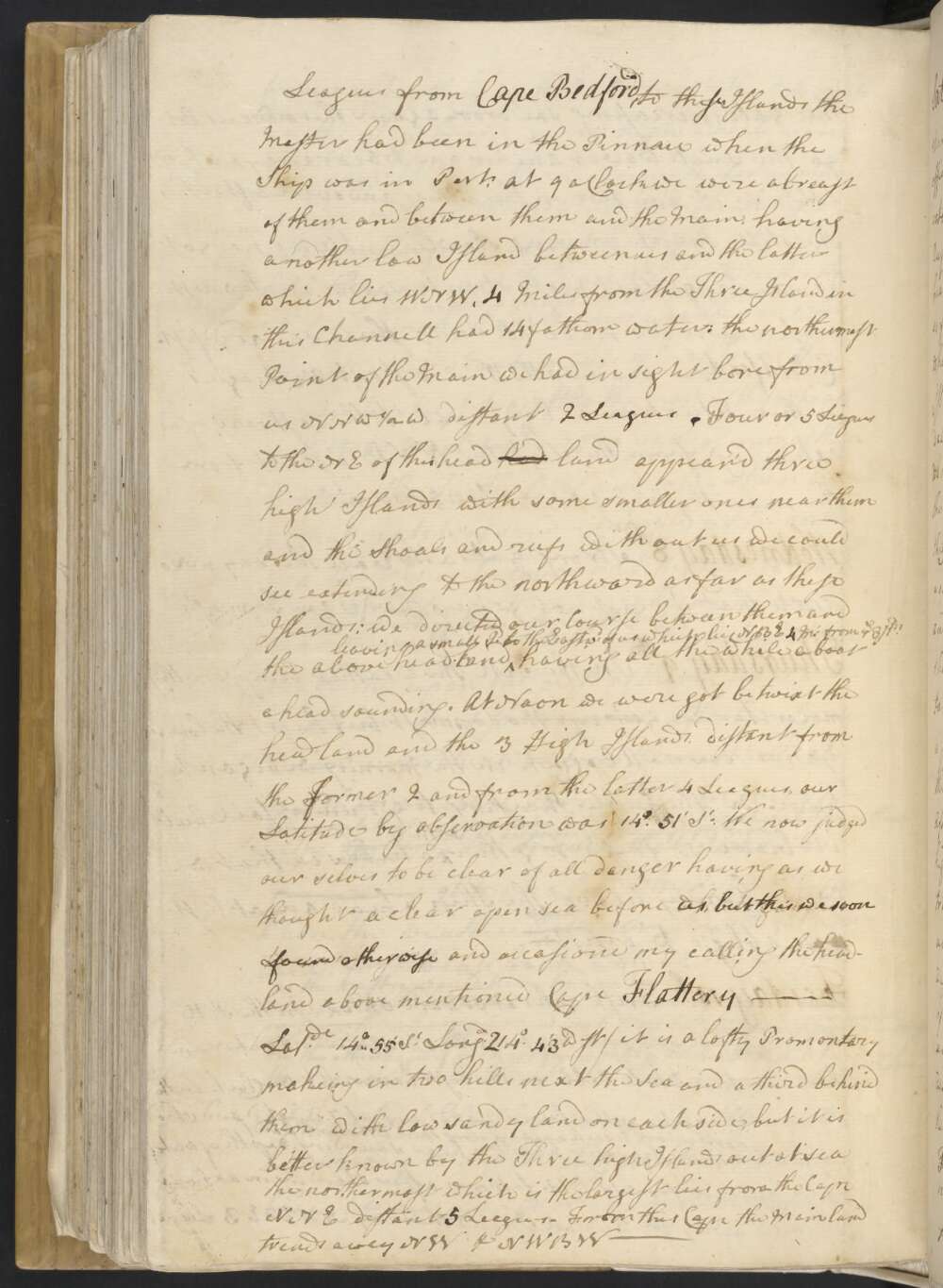
after standing in an hour we edge'd away for 3 small Island that lay NNE ½ E 3 Leagues from Cape Bedford, to these Islands the Master had been in the Pinnace when the Ship was in Port; At 9 oClock we were abreast of them and between them and the Main having another low Island between us and the latter which lies WNW, 4 Miles from the Three Island in this Channell had 14 fathom water: the northermost Point of the Main we had in sight bore from us NNW ½ W distant 2 Leagues. Four or 5 Leagues to the NE of this head lad land appear'd three high Islands with some smaller ones near them and the Shoals and reefs without us we could see extending to the northward as far as these Islands:
we directed our Course between them and the above headland leaving a small Id to the Eastwd of us which lies NBE 4 M. from ye 3 Ids having all the while a boat ahead sounding. At Noon we were got betwixt the headland and the 3 High Islands distant from the former 2 and from the latter 4 Leagues, our Latitude by observation was 14°..51' St
We now judged our selves to be clear of all danger having as we thought a clear open sea before us, but this we soon found otherwise and occasiond my calling the headland above mentioned Cape Flattery — / Latitude 14°..55' St Longd 214° 43' West / it is a lofty Promontary makeing in two hills next the Sea and a third behind them with low sandy land on each side, but it is better known by the Three high Islands out at sea the northermost which is the largest and lies from the Cape NNE distant 5 Leagues — From this Cape the Mainland trends away NW & NWBW —
Thursday 9th In the PM the weather being something moderater we got up the Topmast, but kept the Lower Yards down. A 6 oClock in the Morning we began to heave in the Cable thinking to get under sail, but it blowed so fresh together with a head sea that we could hardly heave the Ship ahead and at last was oblig'd to desist —
Wednesday 8th Strong gales at SSE all this day in so much that I dirst not get up yards and Topmasts
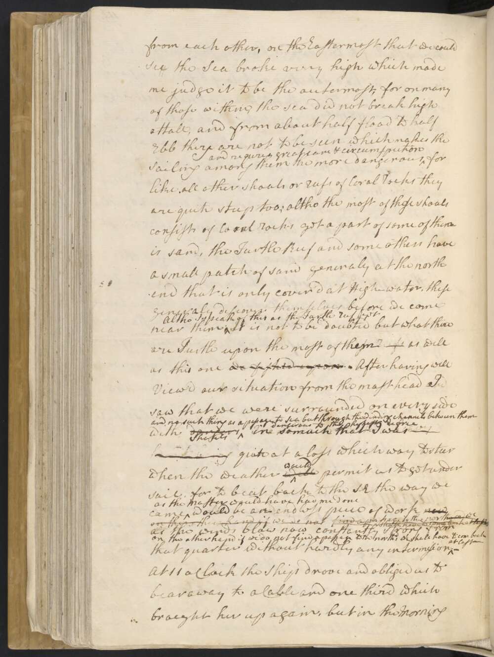
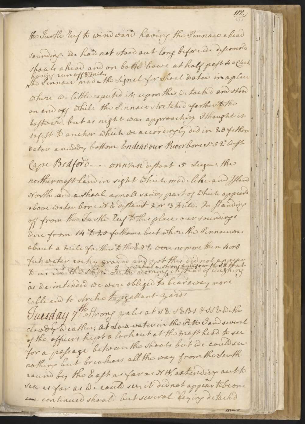
Tuesday 7th Strong gales at SE, SEBS & SSE with clowdy weather, At Low-water in the PM I and several of the officers kept a look out at the Mast head to see for a passage between the Shoals but we could see nothing but breakers all the way from the South round by the East as far as NW, extending out to sea as far as we could see, it did not appear to be one one continued shoal but several laying detach'd from each other,
on the Eastermost that we could see the Sea broke very high which made me judge it to be the outermost, for on many of those within, the sea did not break high attall, and from about half flood to half Ebb they are not to be seen which makes the Sailing among them the more dangerous and requires great care & circumspection for like all other shoals or reefs of Coral Rocks they are quite steep too;
altho the most of these shoals consist of Coral Rocks yet a part of some of them is sand, the Turtle Reef and some others have a small patch of sand generaly at the north end that is only cover'd at High-water, these generaly discover themselves before we come near them Altho I speak of this as the Turtle Reef yet. It is not to be doubted but what there are Turtle upon the most of these reefs them as well as this one we fished upon.
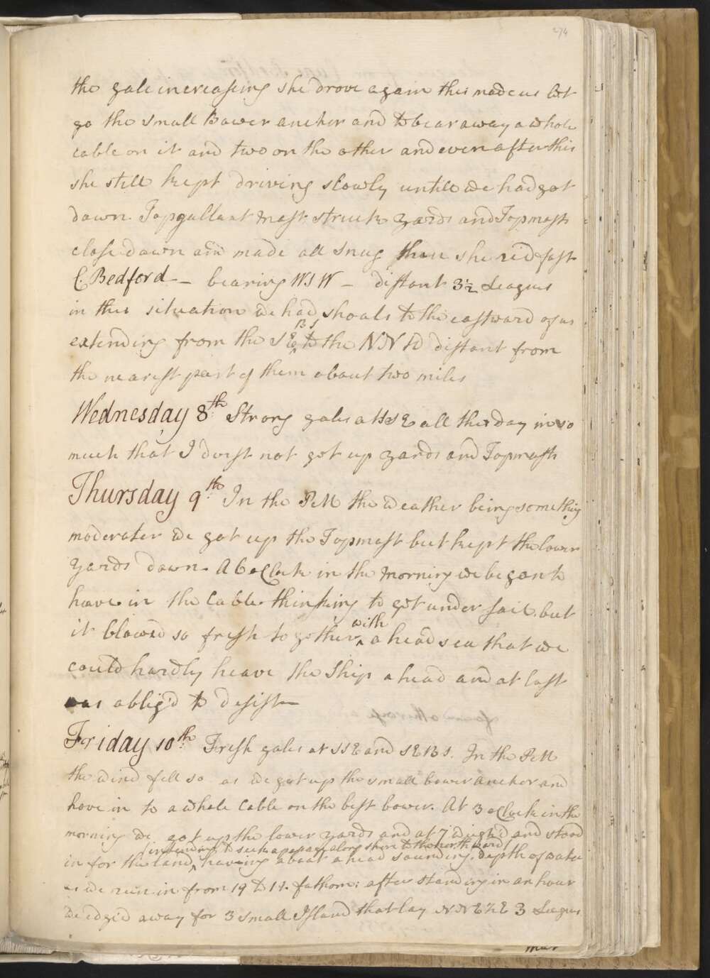
After having well View'd our situation from the mast head and I saw that we were surrounded on every side with dangers Shoals and no such thing as a passage to Sea but through the winding channels between them dangerous to the highest degree in so much that I was quite at a loss which way to steer when the weather will would permit us to get under sail, for to beat back to the SE the way we came as the Master would have had me done would be an endless peice of work now on the other hand if we do not find a passge to the northward we shall have to come back at least as the winds blow now constantly strong from that quarter without hardly any intermission — on the other hand if we do not find a passage to the northd we shall have to come at last —
At 11 oClock the Ship drove and obliged us to bear away to a Cable and one third which brought us up again, but in the Morning the Gale increaseing she drove again this made us let go the Small Bower anchor and to bear away a whole cable on it and two on the other and even after this she still kept driving slowly untill we had got down Topgallant Mast, struck Yards and Topmasts close down and made all Snug than she rid fast C. Bedford — bearing WSW — distant 3½ Leagues in this situation we had shoals to the eastward of us extending from the SEBS to the NNW distant from the nearest part of them about two miles
Monday 6th Winds at SE at 2 oClock in the PM it fell pretty moderate and we got under sail and stood out upon a wind NEBE having the Turtle Reef to windward having the Pinnace ahead sounding, we had not stood out long before we discover'd shoals ahead and on both bows,
at half past 4 oClock having run off 8 Miles the Pinnace made the Signal for shoal water in a place where we little expected it, upon this we tack'd and stood on and off while the Pinnace stretched farther to the Eastward, but as night was approaching I thought it safest to anchor which we accordingly did in 20 fathom water a muddy bottom, Endeavour River bore St 52° West Cape Bedford — WBN ½ N distant 5 Leagues, the northermost land in sight which made like an Island North and a shoal, a small sandy part of which appear'd above water bore NE distant 2 or 3 Miles.
In standing off from the Turtle Reef to this place our soundings were from 14 to 20 fathoms, but where the Pinnace was about a Mile farther to the ENE were no more then 4 or 5 feet of water rocky ground and yet this did not appear to us in the Ship. In the morning we had a strong gale from the SE that instead of weighing as we intended we were obliged to bear away more Cable and to strike topgallant yards
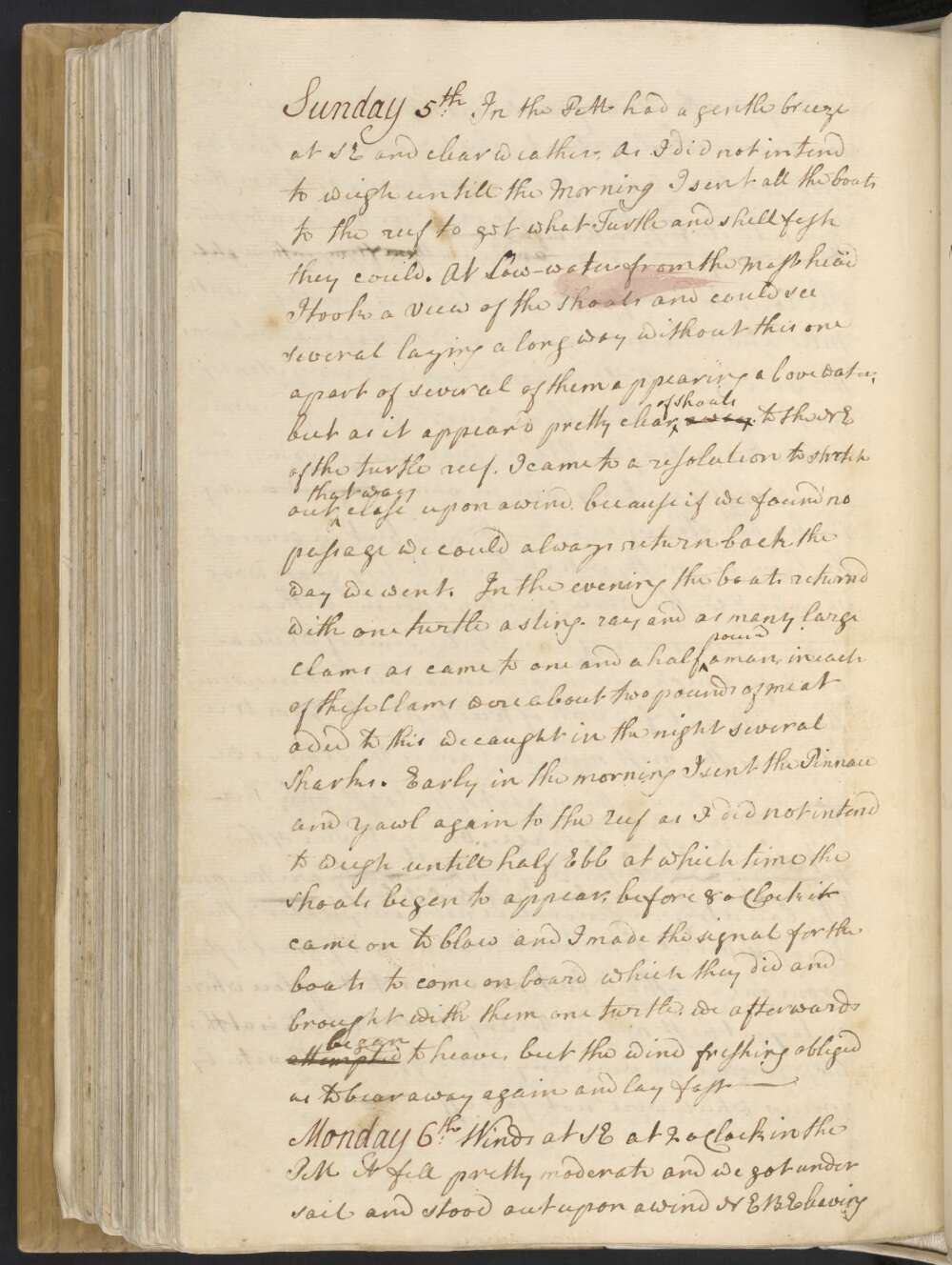
Sunday 5th In the PM had a gentle breeze at SE and clear weather, As I did not intend to weigh untill the Morning I sent all the boats to the reef to get what Turtle and shell fish they could. At Low-water from the Mast head I took a view of the shoals and could see several laying a long way without this one apart of several of them appearing above water, but as it appear'd pretty clear of Shoals away to the NE of the turtle reef, I came to a resolution to stretch out that way close upon a wind, because if we found no passage we could always return back the way we went.
In the evening the boats returnd with one turtle a sting-ray and as many large Clams as came to one and a half pound a man, in each of these Clams were about two pounds of meat added to this we caught in the night several Sharks. Early in the morning I sent the Pinnace and Yawl again to the reef as I did not intend to wiegh untill half Ebb at which time the Shoals began to appear, before 8 oClock it came on to blow and I made the signal for the boats to come on board which they did and brought with them one turtle. We afterwards attempted began to heave, but the wind freshing obliged us to bear away again and lay fast —
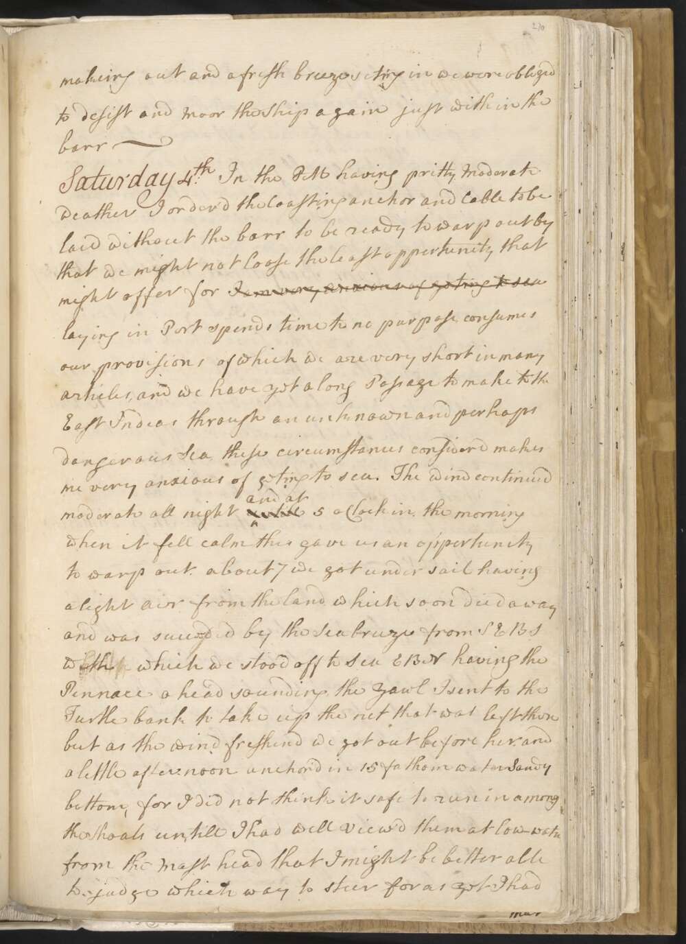
Saturday 4th In the PM having pritty Moderate weather I order'd the Coasting anchor and Cable to be laid without the barr to be ready to warp out by, that we might not loose the least oppertunity that might offer for I am very Anxious of geting to Sea laying in Port spends time to no purpose, consumes our provisions of which we are very Short in many articles, and we have yet a long Passage to make to the East Indias through an unknown and perhaps dangerous Sea, these circumstances considerd, makes me very anxious of geting to sea.
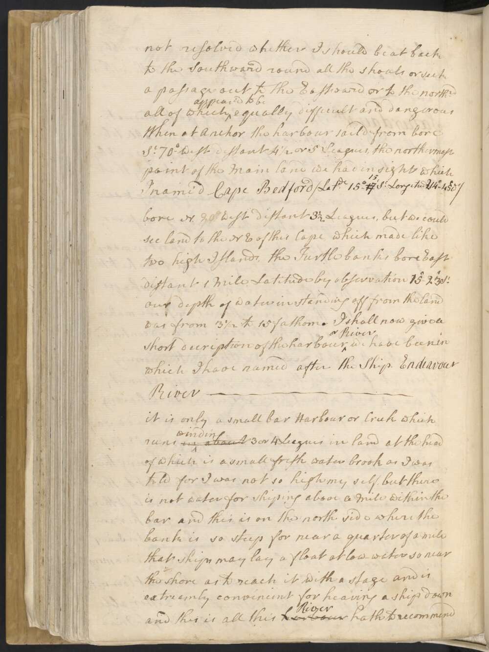
The wind continued moderate all night untill and at 5 oClock in the morning when it fell calm this gave us an oppertunity to warp out. about 7 we got under sail having a light air from the land which soon died away and was succeeded by the Sea breeze from SEBS with which we stood off to Sea EBN having the Pinnace ahead sounding, the Yawl I sent to the Turtle bank to take up the net that was left there but as the wind freshen'd we got out before her, and a little after noon anchor'd in 15 fathom water Sandy bottom, for I did not think it safe to run in among the Shoals untill I had well View'd them at low-water from the Mast head, that I might be better able to judge which way to steer for as yet I had not resolved whether I should beat back to the Southward round all the shoals or seek a passage to the Eastward or to the northrd all of which appear'd to be equally difficult and dangerous
When at Anchor the harbour sail'd from bore St 70° West distant 4½ or 5 Leagues, the northermost point of the Main land we had in sight which I name'd Cape Bedford / Latde 15°..1715' St Longitude 1214°..45' Wt / bore N. 20° West distant 3½ Leagues, but we could see land to the NE of this Cape which made like two high Islands, the Turtle banks bore East distant 1 Mile, Latitude by observation 15°..23' St our depth of water in standing off from the land was from 3½ to 15 fathom.
I shall now give a Short decription of the harbour or River we have been in which I named after the Ship. Endeavour River —
it is only a small bar Harbour or Creek which runs in about winding 3 or 4 Leagues in land at the head of which is a small fresh water brook as I was told for I was not so high myself, but there is not water for shiping above a Mile within the bar and this is on the north side where the bank is so steep for nearly a quarter of a mile that ships may lay a float at low-water so near the shore as to reach it with a stage and is extreamly convineint for heaving a ship down
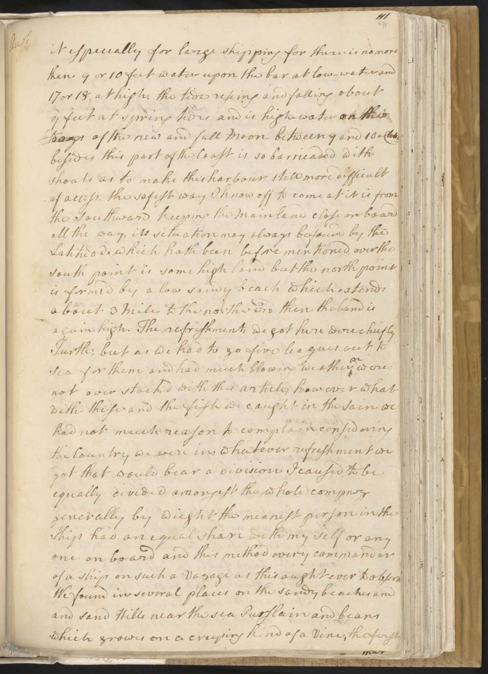
and this is all this harbour River hath to recommend it especially for large shipping for there is no more than 9 or 10 feet water upon the bar at low-water and 17 or 18 feet at high, the tides riseing and falling about 9 feet at spring tides and is high-water on the days of the new and full Moon between 9 and 10 oClock besides this part of the Coast is so barricaded with shoals as to make this harbour still more difficult of access, the safest way I know off to come at it is from the Southward keeping the Mainland close on board all the way, its situation may always be found by the Latitude which hath been before mentioned, over the South point is some high land but the north point is forme'd by a low sandy beach which extends about 3 Miles to the northward then the land is again high.
The refreshments we got here were chiefly Turtle, but as we had to go five Leagues out to Sea for them and had much blowing weather we were not over stock'd with this article, however what with these and the fish we caught in the Sain we had not much reason to complain considering the Country we were in, whatever refreshment we got that would bear a division I caused to be equally divided amongest the whole compney generally by weight, the meanest person in the Ship had an equal share with my self or any one on board and this method every commander of a Ship on such a Voyage as this ought ever to observe
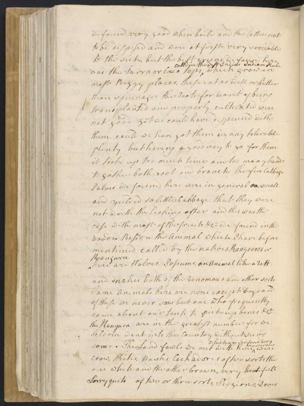
We found in several places on the sandy beaches and sand Hills near the Sea Purslain and beans which growes on a creeping kind of a Vine, the first we found very good when boild and the latter not to be despised and were at first very servicable to the sick, but the best greens we found here was the Tarra or Cocco tops called in the West Indias Indian Kale which grow in most Boggy places, these eat as well as or better than spinnage, the roots for want of being transplanted and properly cultivated were not good yet we could have dispenced with them could we have got them in any tolerable plenty but having a good way to go for them it took up too much time and too many hands to gather both root and branch: the few Cabbage Palms we found here were in general so small and yeilded so little Cabbage that they were not worth the looking after and this was the case with most of the fruits &Ca we found in the woods.
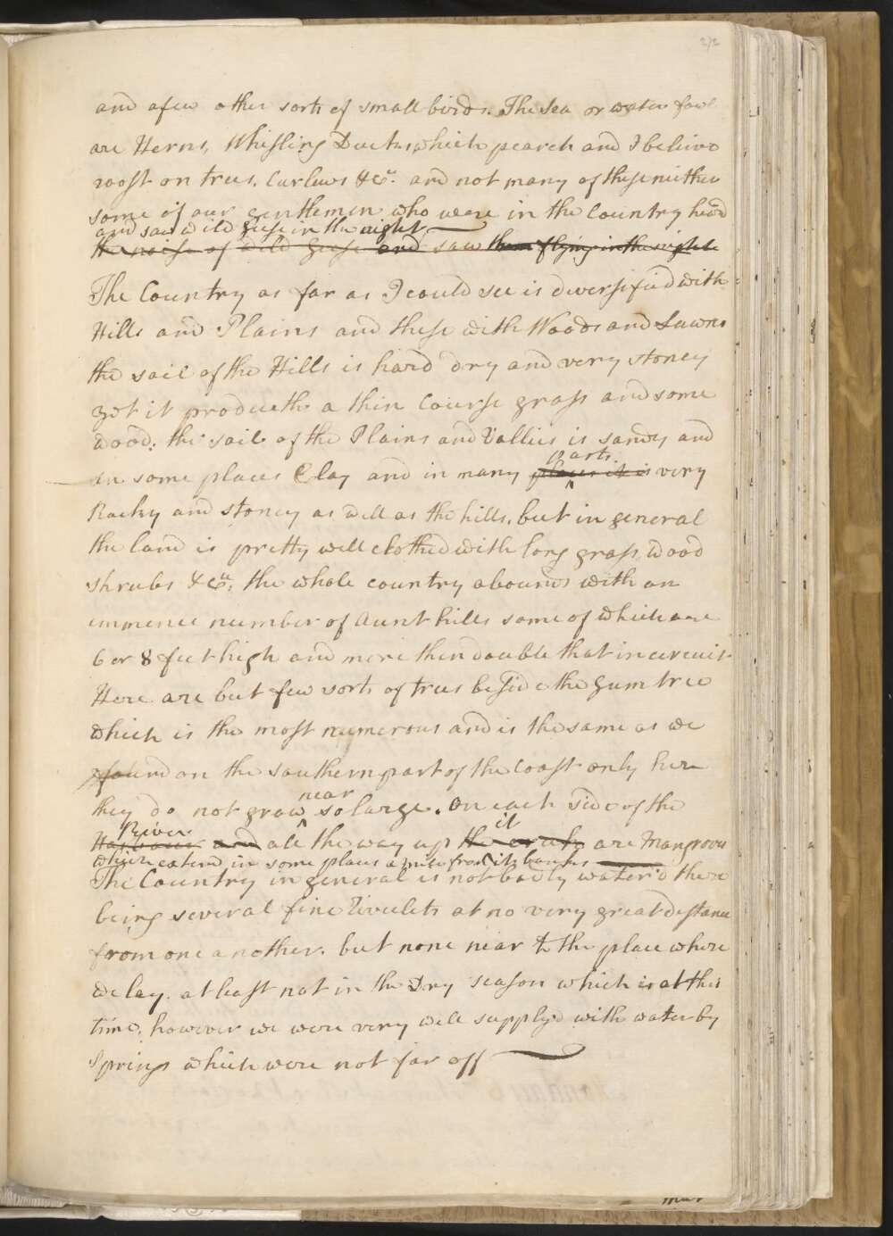
Besides the Animal which I have before mentioned called by the natives Kangooroo or Kanguru here are Wolves, Possums, an Animal like a ratt and snakes both of the Venomous and other sorts Tame Animals here are none except Dogs and of these we never saw but one who frequently came about our tents to pick up bones &Ca The Kangura are in the greatest number for we seldom went into the Country without seeing some. The Land fowls we met with here which far from being numerous were Crows, Kites, Hawks, Cockadores of two sorts the one white and the other brown, very beautifull Lorryquets of two or three sorts, Pidgions, Doves and a few other sorts of small birds. The Sea or water fowl are Herns, Whisling Ducks which pearch and I beleive roost on trees, Curlews &Ca and not many of these neither some of our Gentlemen who were in the Country heard the noise of Wild Geese and saw them flying in the night and saw wild Geese in the Night —
The Country as far as I could see is deversified with Hills and Plains and these with Woods and Lawns the soil of the Hills is hard dry and very stoney yet it produ[c]eth a thin Course grass and some wood: the soil of the Plains and Vallies is sandy and in some places Clay and in many places it is parts very Rocky and stoney as well as the hills, but in general the land is pretty well clothed with long grass, wood, shrubs &Ca The whole country abounds with an immence number of Aunt hills some of which are 6 or 8 feet high and more than double that in circuit Here are but few sorts of trees besides the Gum tree which is the most numerous and is the same as we found on the Southern part of the Coast only here they do not grow near so large. On each side of the Harbour River and all the way up the creek it are Mangroves which extend in some places a Mile from its banks —
the Country in general is not badly water'd there being several fine Rivulets at no very great distance from one another, but none near to the place where we lay, at least not in the Dry season which is at this time, however we were very well supply'd with water by Springs which were not far off —
Friday 3rd In the PM the weather being more moderate we carried the coasting anchor and Cable out and laid it without the barr in order to be ready to warp out by that we may not loose the least opportunity that may offer Strong breezes and hazy untill 6 oClock in the AM when it Moderated and we unmoord hove up the anchor and began to warp out but the Ship tailing upon the sand on the north side of the harbour River, the Tide of Ebb makeing out and a fresh breeze seting in we were obliged to desist and Moor the Ship again just within the barr —
Thursday 2nd Winds and weather as yesterday or rather more stormy. We have now no success in the Sain fishing hardly geting above 20 or 30 pound the day —
Wednesday 1st Strong gales from the SE with Squals attended with rain.
In the PM the Yawl came in with two rays which together weigh'd 265 lb it blowed too hard all the time they were out for strikeing turtle. Carpenters employ'd overhauling the Pumps all of which we find in a state of decay and this the Carpenter says is owing to the sap having been left on which in time has decay'd the sound wood. one of them is quite useless and was so rotten when hoisted up as to drop to pieces, however I cannot complain of a leaky ship for the most water she makes is not quite an Inch an hour —
Explore more of Cook's Journal